The lithosphere, Earth’s outmost layer, is a complex and intricate system comprising the crust and a portion of the uppermost mantle. This layer is composed of several tectonic plates constantly moving on Earth’s surface. According to the theory of plate tectonics, lithospheric deformation primarily occurs in the narrow regions near the active plate boundaries due to the relative motion between the adjacent plates. Besides, the plates’ interior is considered rigid and free from deformation. However, it has long been observed that earthquakes can occur in areas hundreds to thousands of kilometers away from the active plate boundaries, particularly on continents. Recent advancements in geodesy, such as the use of the Global Positioning System (GPS), have further substantiated active intraplate deformation in many regions globally.
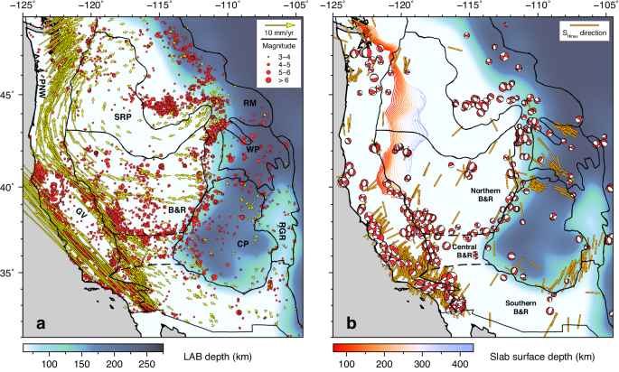
The western United States (WUS) is one of the best examples of enduring intraplate deformation. Currently, the WUS displays a spatially broad and complex deformation pattern with frequent intracontinental earthquakes and widely distributed crustal motion relative to the stable North American plate (Fig. 1a). The driving mechanism for the WUS intraplate deformation is still poorly understood, particularly for the remarkable north-south-trending Intermountain Seismic Belt (ISB; Fig. 1b). The ISB, which stretches from the southern Colorado Plateau to the northern Rocky Mountain, has intense seismicity and lies thousands of kilometers away from the active plate boundaries with an enigmatic origin. In addition, WUS intracontinental earthquakes frequently occur in densely populated regions (Fig. 1b), causing catastrophic impacts on people, infrastructure, and the natural environment. Therefore, understanding the driving mechanism for WUS intraplate deformation is not just a scientific pursuit of understanding Earth’s tectonics but a crucial step toward better preparing people for future earthquake threats.
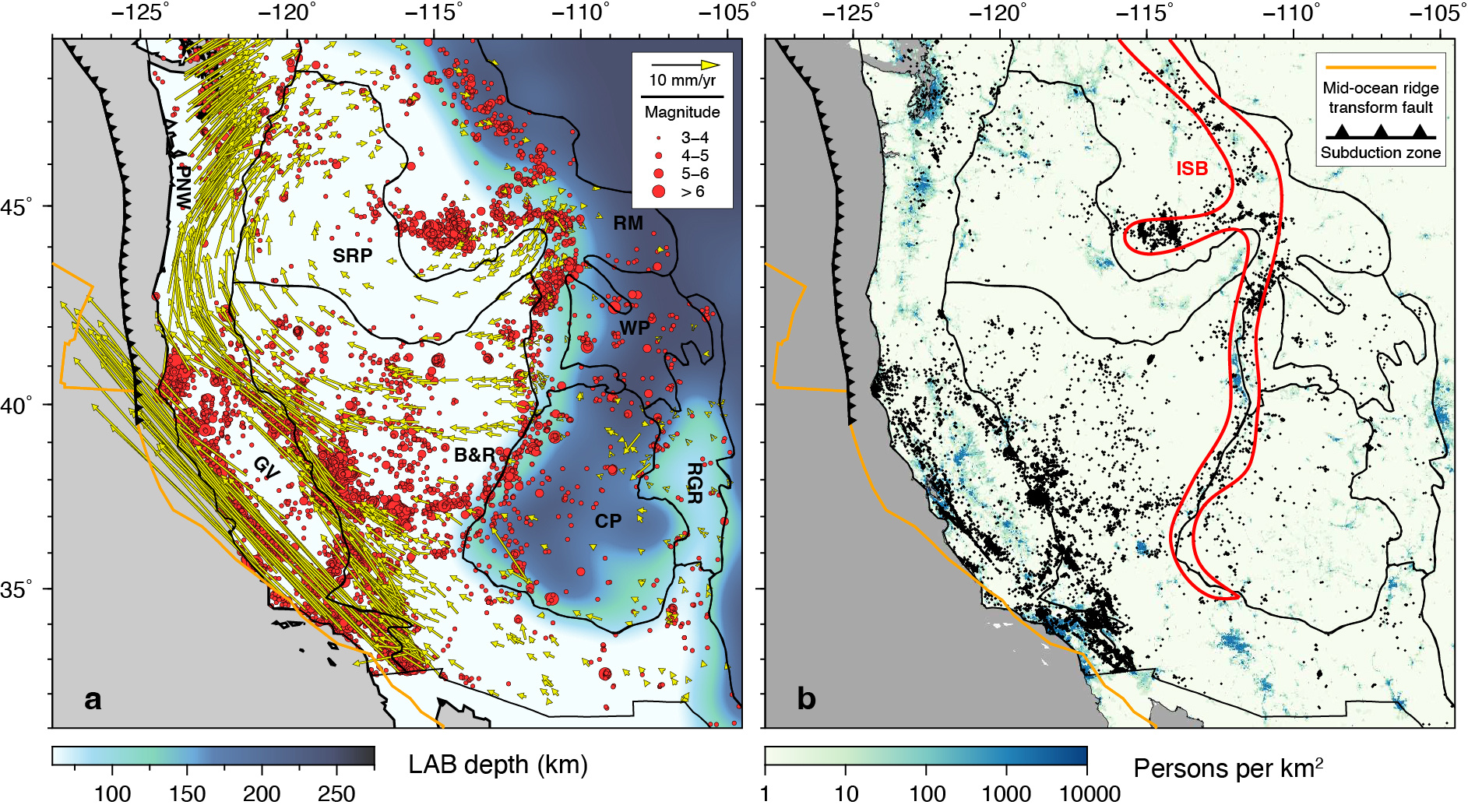
Fig. 1 Crustal deformation features, lithospheric thickness, and population distribution in the WUS. (a) Seismicity and geodetically measured crustal motion overlying the LAB depth. Red dots indicate earthquake epicenters from 1980 to 2020, with the radius showing magnitudes (from USGS). Yellow arrows indicate crustal motion relative to the stable North American plate, as determined by GPS measurements (from GAGE/UNAVCO). (b) Seismicity (black dots) overlying the population distribution. In (b), the red contour outlines the Intermountain Seismic Belt. In both panels, black lines represent major tectonic provinces, and the plate boundaries are from Müller et al. (2016). PNW: Pacific Northwest, GV: Great Valley, SRP: Snake River Plain, B&R: Basin and Range, RM: Rocky Mountain, WP: Wyoming Plateau, CP: Colorado Plateau, RGR: Rio Grande Rift, ISB: Intermountain Seismic Belt.
The driving mechanism for WUS intraplate deformation has been debated for decades. The proposed driving forces broadly fall into three categories: 1) the long-range plate boundary forces due to the interaction between the Pacific plate and the North American plate and subduction of the Juan de Fuca plate, 2) the lithospheric body forces arising from the inhomogeneous lithospheric density structure and surface topography, and 3) the viscous drag exerted by the underlying mantle flow. Many studies have been devoted to understanding the cause of WUS intracontinental deformation. Still, more consensus has yet to be reached, mainly due to inconsistent assumptions on the lithospheric and convective mantle structures in prior estimations.
Traditional studies on lithospheric dynamics usually treated the lithosphere as a two-dimensional (2D) thin shell. Under this thin-shell approximation, the lithosphere was assumed to have a constant thickness with a presumed lithosphere-asthenosphere boundary (LAB) at 100 km depth and vertically uniform physical properties. The surface topography was considered to be fully supported by lithospheric density anomalies above the LAB. Besides, the convecting mantle was only allowed to exert horizontal shear along the flat LAB, and the horizontal shear was often estimated from mantle convection models that only considered deep long-wavelength density anomalies. These simplifications may lead to an incomplete understanding of the complex processes at play and are questioned by recent seismological, geophysical, and geodynamic studies.
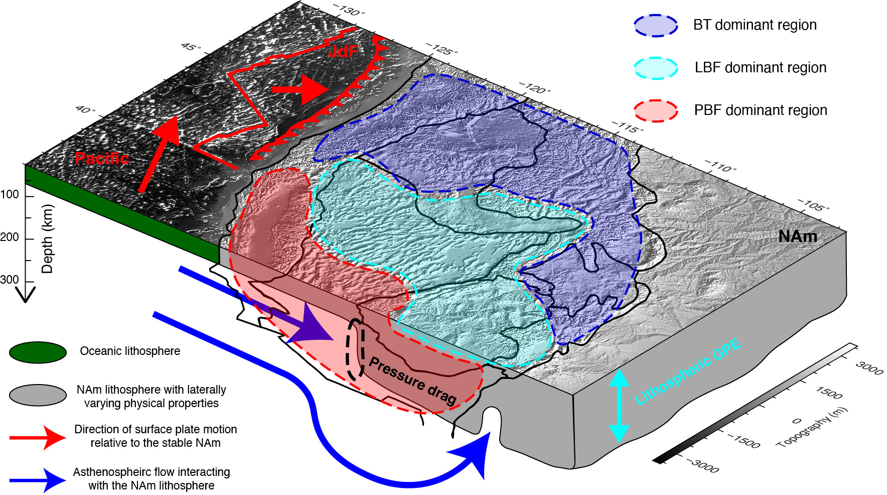
Seismological studies have revealed that the LAB depth has significant lateral variations on both global and regional scales. In some regions, like the WUS, LAB depth can have large lateral gradients and reach a depth as deep as 250 km (Fig. 1a). A continental lithosphere with laterally varying thickness may actively interact with the convecting mantle, as supported by recent geodynamic studies (e.g., Zhou et al., 2018). This interaction will generate complex surface tractions along the undulating LAB, compromising both shear and normal forces that may not be adequately resolved in previous estimations assuming a flat LAB. Notably, the enigmatic ISB shows a good spatial correlation to the lithospheric thickness step in the WUS (Fig. 1), strongly implying its association with the localized lithosphere-asthenosphere interaction.
In addition, recent seismological and geophysical studies, like attenuation and magnetotelluric tomography models, showed that the continental lithosphere has substantial 3D variations in physical properties, hinting that the continental lithosphere cannot be treated as a thin shell with vertically uniform physical properties. Furthermore, geodynamic studies showed that the vertical stress exerted along the LAB by the underneath mantle flow can maintain a significant portion of surface topography (i.e., dynamic topography), contrasting the lithospheric isostasy adopted in the thin-shell approximation. Also, some recent geological and geophysical studies showed that the continental lithosphere has a complex, layered density structure, which is critical for understanding lithospheric deformation processes and the origin of surface topography. However, it was not considered in conventional thin-shell models.
Given the complexity of the 3D lithospheric structure, which has often been oversimplified in previous studies, it is imperative to systematically explore its links to the proposed driving forces and their associated crustal deformation. This comprehensive approach is necessary to gain a deeper understanding of the driving mechanism for WUS intracontinental deformation and can potentially advance our understanding of lithospheric deformation processes.
In our recent study (Cao and Liu, 2024), we delved into the effects of complex 3D lithospheric structure on WUS intracontinental deformation. We developed a series of data-driven 3D dynamic models that comprehensively simulate lithospheric and convective mantle processes within a unified physical framework. Our best-fitting model not only predicted a mantle flow field consistent with the recent observation of azimuthal anisotropy but also replicated the distribution of seismicity and GPS-determined surface relative motion in the WUS (Fig. 2). Through systematic analysis, we discovered that the locally enhanced lithosphere-asthenosphere interaction, a result of the thick cratonic lithosphere blocking the landward mantle flow along the lithospheric thickness step (Fig. 2a), plays a pivotal role in generating localized high crustal deformation rate and leads to the formation of ISB with intense intraplate seismicity (Fig. 2b).
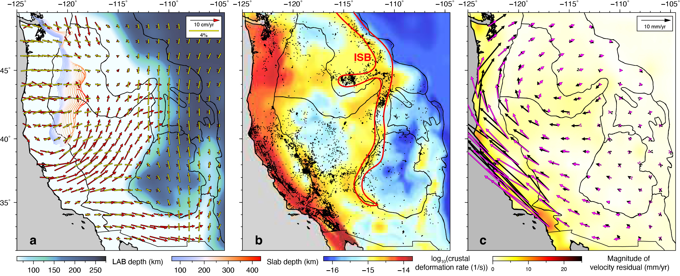
Fig. 2 Comparisons between model predictions and geophysical observations in the WUS. (a) Predicted horizontal mantle flow at 150 km depth relative to the stable North American plate and observed azimuthal seismic anisotropy (yellow bars show the fast-propagating direction of shear waves; Zhu et al., 2020) at 100 km overlying the LAB depth. The colored contours indicate the upper surface of the Juan de Fuca slab at different depths. (b) Earthquake epicenters from 1980 to 2020 overlying predicted crustal deformation rate. (c) Predicted (magenta arrows) and observed (black) surface motion overlying the magnitude of their residuals.
Beyond the WUS, many other regions also exhibit intense intraplate deformation, and most of them are at high risk of earthquake hazards, such as the Mediterranean, East Asia, and Tibet Plateau. In these regions, the lithosphere may have a complex 3D structure due to long-term thermochemical and tectonic evolution; it may also actively interact with the underlying mantle flow driven by the deep Tethyan slabs. Given this layer of complexity, we emphasize the necessity of considering the role of 3D lithospheric structure and its interaction with mantle flow when quantitatively studying lithospheric deformation in these regions.
References:
Cao, Z. & Liu, L. Western US intraplate deformation controlled by the complex lithospheric structure. Nat Commun 15, 3917 (2024).
Müller, R. D. et al. Ocean basin evolution and global-scale plate reorganization events since Pangea Breakup. Annual Review of Earth and Planetary Sciences 44, 107–138 (2016).
Zhu, H., Yang, J. & Li, X. Azimuthal anisotropy of the North American upper mantle based on full waveform inversion. Journal of Geophysical Research: Solid Earth 125, (2020).
Zhou, Q. et al. Western U.S. seismic anisotropy revealing complex mantle dynamics. Earth and Planetary Science Letters 500, 156–167 (2018).
Follow the Topic
-
Nature Communications
An open access, multidisciplinary journal dedicated to publishing high-quality research in all areas of the biological, health, physical, chemical and Earth sciences.

Related Collections
With Collections, you can get published faster and increase your visibility.
Women's Health
Publishing Model: Hybrid
Deadline: Ongoing
Tumor Microenvironment Crosstalk and Therapeutic Implications
Publishing Model: Hybrid
Deadline: Nov 02, 2026


Please sign in or register for FREE
If you are a registered user on Research Communities by Springer Nature, please sign in