The Lake Trophic State-US dataset: A new tool to track continental-scale lake productivity
Published in Social Sciences, Earth & Environment, and Ecology & Evolution

Explore the Research

National-scale remotely sensed lake trophic state from 1984 through 2020 - Scientific Data
Scientific Data - National-scale remotely sensed lake trophic state from 1984 through 2020
In June 2018, I attended my first scientific conference. Among all the excitement, Dina Leech’s talk stuck out in my mind. She presented on a collaborative study with Amina Pollard and Stephanie Hampton (Leech et al., 2018), where they applied the Nutrient-Color Paradigm to the U.S. Environmental Protection Agency’s National Lakes Assessment (NLA). Their study aimed to disentangle how lakes might be shifting in biological productivity at the continental scale. I was so impressed that such a sophisticated analysis could come from a straightforward metric like color. I was beginning to get involved in remote sensing of lake ecosystems, and I was convinced remote sensing imagery could be used as a tool to understand shifts in lake color. However, I was entering the end years of my doctoral work, so starting a new project was outside my bandwidth.
Fast forward to 2020. The global COVID pandemic completely altered how we professionally and personally engaged with each other. However, it also empowered the rise of virtual conferences, and consequently, I attended the 2020 Ecological Society of America virtual meeting. I tried to watch as many early career researchers’ talks as possible, and I stumbled upon two talks that reignited my intrigue in remote sensing of lake color. Isabella Oleksy presented an analysis of how lake metabolism for blue, green, and brown lakes could be explained by a suite of hydrologic and land-use data (Oleksy et al., 2022). Simon Topp presented on remotely sensed changes in lake color over the Landsat timeseries (Topp et al., 2021). These presentations motivated me to begin my own exploration of lake color.
In 2021, I joined the U.S. Geological Survey as a Mendenhall Fellow and became integrated into a project that used remote sensing to determine water quality in surface-water systems. I finally had the time and opportunity to devote myself to this admittedly daunting idea of combining Dina, Amina, Stephanie, Simon, and Bella’s work to empower a suite of analyses aimed at remotely sensing lake color, relating color with crucial ecological states, and then eventually assessing their drivers. What started as a dream project quickly ballooned into a dynamic, interdisciplinary collaboration, where those who inspired the idea of remotely sensing aquatic ecosystem productivity became some of its biggest proponents - eventually leading to the Lake Trophic State - US dataset (LTS-US).

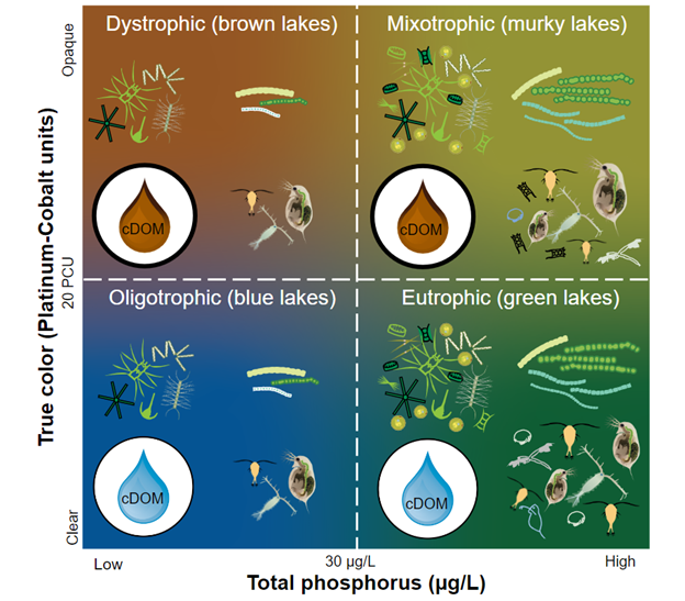
Trophic state is a metric that provides a holistic assessment of a lake’s aggregate physical, chemical, and biological processes. Broadly speaking, trophic state is a property closely associated with a lake’s productivity as well as its color. Eutrophic lakes are green, oligotrophic lakes are blue, and dystrophic lakes are brown. From color-trophic state connections, fundamental limnological principles center around linking trophic states to characteristic properties. In a policy context, the concept of trophic state is included in the U.S. Clean Water Act, which focuses on the “identification and classification [of lakes] according to eutrophic condition,” where eutrophic conditions can trigger “procedures, processes, and methods…to control sources of pollution and…to restore [water quality].”
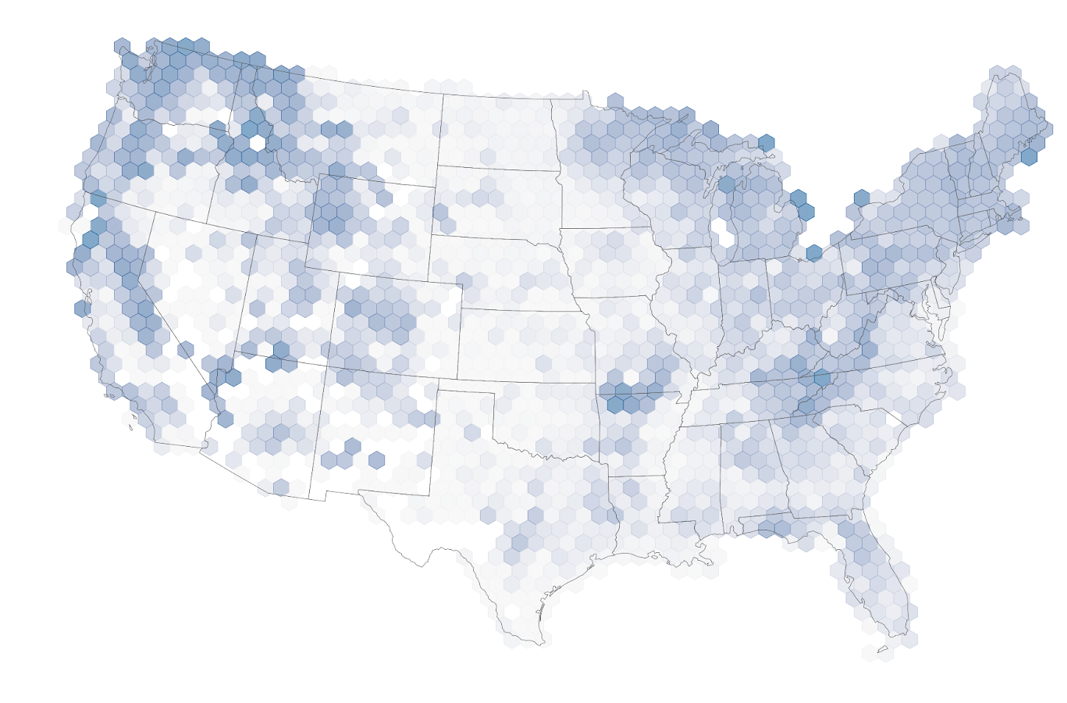
Here, we present the LTS-US, a compendium of lake trophic state estimates for 55,662 lakes throughout the contiguous United States 1984-2020. The work brings together continental-scale sampling efforts from the NLA with the Landsat archive to create a training dataset of in situ water quality and characteristic surface reflectance values. This work is the first to relate surface reflectances with trophic state using the Nutrient-Color Paradigm, which can provide a foundation to improve understanding of national-scale trends in and causes of greening (eutrophication), bluing (oligotrophication), and browning (dystrophication). Most notably, the LTS-US dataset can reproduce water quality trends from the NLA, even though predictive models only know a lake's red, green, blue, and near-infrared bands. By replicating trends and patterns from the NLA, the LTS-US provides information of water quality trends for tens of thousands of lakes which is more than could ever be sampled synoptically and for 23 years prior to the implementation of the NLA. Reciprocally, the LTS-US can benefit the NLA’s extensive variable content, where lake non-optical water quality patterns can be related to trophic state, and likewise projected across national scales.
Beyond the dataset’s contribution to the aquatic sciences, the LTS-US dataset is designed for computational reproducibility and customization. All scripts used to create the LTS-US are written in R, an open-source coding language, and use the ‘targets’ package for reproducibility. This pipeline structure enables the LTS-US dataset to be updated (1) as new satellite imagery becomes available and (2) as successive NLA sampling campaigns occur. Further, the ‘targets’ pipeline is incorporated in a Docker container, which enables users to run the pipeline regardless of differences of operating systems.
The LTS-US dataset contains 35 years of critical ecological information for over 55,000 lakes. By coupling satellite-based remote sensing with fundamental limnological principles, the LTS-US dataset provides the means to apply crucial freshwater science frameworks at the national scale to identify macroscale patterns and trends in LTS. Further, this approach moves beyond remote sensing of individual parameters to enable holistic insights into lakes’ physical, chemical, biological, and ecosystem properties.
This work stands on the shoulders of all of those that came before us. Each co-author’s previous works, expertise, and energy allowed for the inspiration that started this project to grow. It is truly a joy to have this product available to the larger scientific community, and we hope that it inspires others to further the science.
Citation for LTS-US Dataset:
Meyer, M.F., S.N. Topp, T.V. King, R. Ladwig, R.M. Pilla, H.A. Dugan, J.R. Eggleston, S.E. Hampton, D.M. Leech, I.A. Oleksy, J.C. Ross, M.R. Ross, R.I. Woolway, X. Yang, M.R. Brousil, K.C. Fickas, J.C. Padowski, A.I. Pollard, J. Ren, and J.A. Zwart. 2023. National-scale, remotely sensed lake trophic state (LTS-US) 1984-2020 ver 1. Environmental Data Initiative. https://doi.org/10.6073/pasta/212a3172ac36e8dc6e1862f9c2522fa4.
Citation for LTS-US Data Paper:
Meyer, M.F., Topp, S.N., King, T.V., Ladwig, R., Pilla, R.M., Dugan, H.A., Eggleston, J.R., Hampton, S.E., Leech, D.M., Oleksy, I.A., Ross, J.C., Ross, M.R.V., Woolway, R.I., Yang, X., Brousil, M.R., Fickas, K.C., Padowski, J.C., Pollard, A.I., Ren, J., Zwart, J.A., 2024. National-scale remotely sensed lake trophic state from 1984 through 2020. Sci Data 11, 77. https://doi.org/10.1038/s41597-024-02921-0.
The LTS-US Dataset in the news:
- LTS-US selected as Environmental Data Initiative’s Feature Dataset: https://edirepository.org/featured/featured-20231017.00
- LTS-US selected as a USGS Open Science Success Story: https://www.usgs.gov/special-topics/year-of-open-science/news/lake-trophic-state-us-dataset
Disclaimer: Any use of trade, firm, or product names is for descriptive purposes only and does not imply endorsement by the U.S. Government.
Follow the Topic
-
Scientific Data

A peer-reviewed, open-access journal for descriptions of datasets, and research that advances the sharing and reuse of scientific data.
Related Collections
With Collections, you can get published faster and increase your visibility.
Data for crop management
Publishing Model: Open Access
Deadline: Apr 17, 2026
Data to support drug discovery
Publishing Model: Open Access
Deadline: Apr 22, 2026


Please sign in or register for FREE
If you are a registered user on Research Communities by Springer Nature, please sign in