Towards a high-resolution time-variable gravity field model for sub-regional scale investigations
Published in Earth & Environment
It all started with a discussion with Prof. Shi Chen in mid-2019. At that time, I was a postdoc at Institute of Geophysics, China Earthquake Administration, and Prof. Chen was my mentor. We discussed the time-variable gravity measurements and their applications in North China. The term "time-variable" refers to the fact that the Earth's gravity varies across locations and over time. These variations in gravity over time are primarily due to mass variations within the Earth system (e.g., water storage change, glaciers and ice sheet melting, and large earthquakes). We can improve our understanding of the changing Earth by tracking and measuring these time-variable variations. The Gravity Recovery And Climate Experiment (GRACE) launched in 2002, and its Follow-on mission (GRACE-FO) launched in 2018 are unique tools for such a purpose. GRACE/GRACE-FO can generate a new map of the Earth’s gravity field every 30 days at a spatial resolution of ~300 km. Over the years, gravity measurements from GRACE/GRACE-FO have played an essential role in studying large-scale mass variation and redistribution over the globe, including the extensive groundwater depletion in North China (especially in the North China Plain).
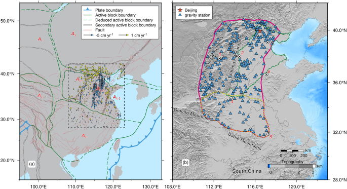
Despite many successful applications in North China, accurately quantifying mass variation at small scales is still challenging due to the coarse spatial resolution of GRACE/GRACE-FO measurements. How can we develop a new time-variable gravity field model with higher spatial resolution? Prof. Chen suggested including terrestrial time-variable gravity measurements in the modeling process. These measurements were collected at the Earth’s surface by regularly observing all stations within a network in North China. The distance between adjacent stations in this network ranges from several hundred meters to approximately 200 km. Consequently, these terrestrial gravity measurements can provide information at a higher spatial resolution than the GRACE results. Moreover, terrestrial gravity measurements are more accurate at short wavelengths due to the inherent signal attenuation with altitude of the gravity field.
Fueled by excitement and anticipation, we started our modeling endeavors with simulated experiments. After several rounds of experimentation, we selected Slepian functions to model the regional gravity field. However, we quickly encountered major challenges, particularly the broadband leakage. Broadband leakage arises from the discrepancy between the maximum expansion degree N and that contained in the input gravity measurements (infinity). When modeling a degree N field, the high degree (>N) components in the input signal will affect the estimation of the coefficients at lower degrees (≤N). Although broadband leakage is an essential issue in Slepian analyses, we recognized that few studies have addressed how to mitigate its effects effectively.
The global pandemic hit just as we tried to find a solution to reduce broadband leakage. Unfortunately, our initial solution didn't work well, and to make things worse, I was stuck in Wuhan for about five months. During that challenging period, it was difficult for me to fully commit to the modeling project. Although I came up with several potential solutions, they all failed, adding to my anxiety and stress.
Fortunately, I have the full support of my mentor, Prof. Chen. He was keen on novel methods and techniques. We shifted to the use of online meetings and kept up regular communications. By chance, I came across a fascinating article by Bomfim et al. (2013) that inspired me a lot. After the pandemic, I returned to our lab with a new solution. This solution proved effective, and we published a preliminary result in the Chinese Journal of Geophysics in 2021. After reaching this stage, we aim to refine our modeling approach. Prof. Chen and I often had discussions in his office, and it was during one of these discussions that a novel idea emerged. After a long and challenging journey, our efforts led us to the new model presented in our paper: a degree 150 (with a spatial resolution of ~120 km) time-variable gravity field model solely from terrestrial gravity measurements in North China.
I want to express my heartfelt gratitude to Prof. Chen for his exceptional mentorship and to my co-authors for their unwavering support throughout this journey. I would also like to thank the Gravity Network Centre of China, Hubei Earthquake Agency for providing us with campaign gravity measurements.
This paper summarizes our latest findings, including a good agreement between our model and GRACE up to degree 60 (maximum degree for the GRACE products we used). The gravity changes with a much finer spatial resolution (~120 km) from our model could complement GRACE solutions (~300 km spatial resolution) for sub-regional scale investigations in North China. Our work also paves the way for the combination of satellite (GRACE/GRACE-FO and other gravimetry satellites) and terrestrial measurements.
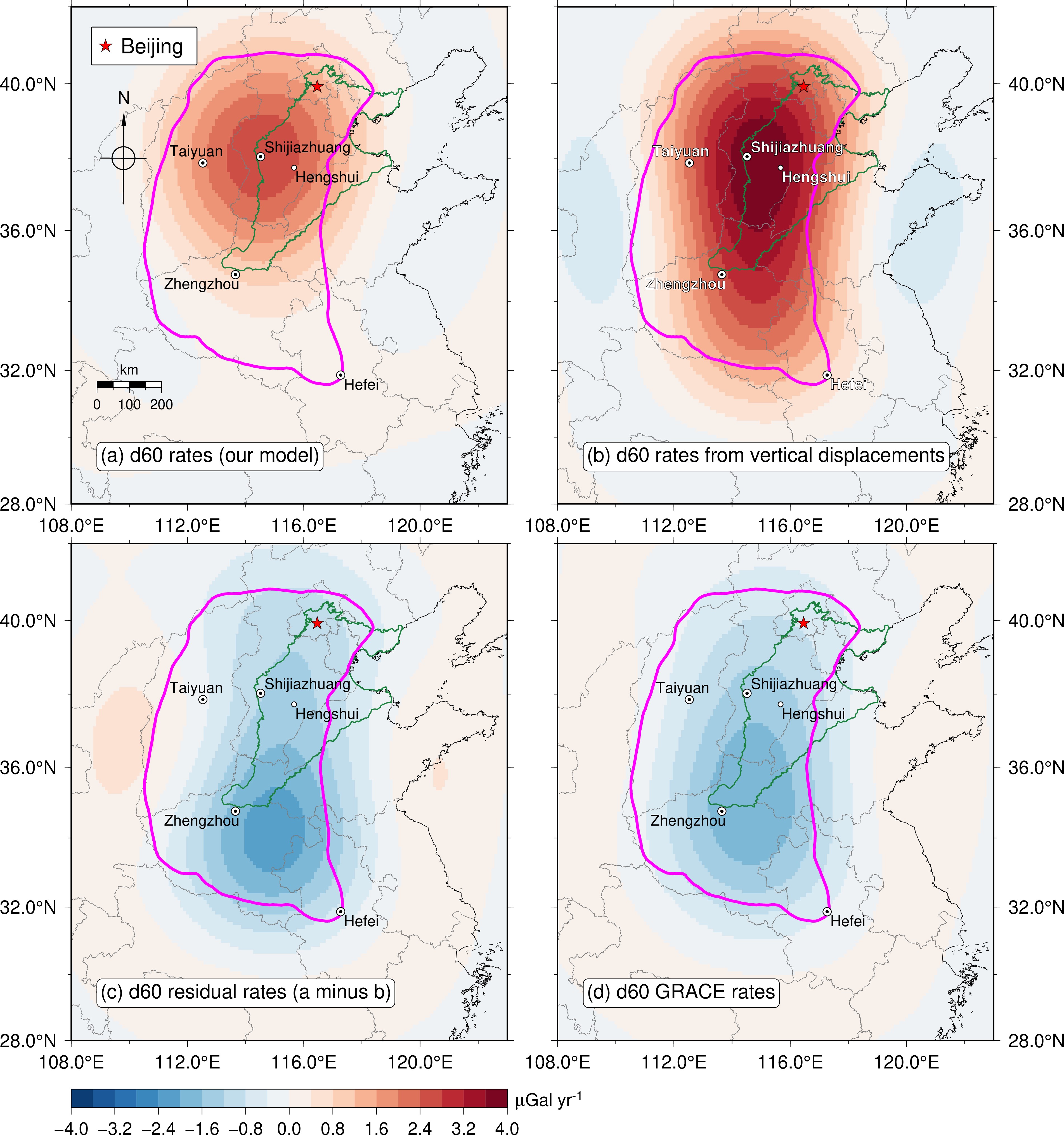
Interested to know more about our findings? Check out our full article published in Communications Earth & Environment: https://www.nature.com/articles/s43247-024-01209-w.
References:
1. Bomfim, E. P., Braitenberg, C. & Molina, E. C. Mutual evaluation of global gravity models (EGM2008 and GOCE) and terrestrial data in Amazon Basin, Brazil. J. Int. 195, 870-882 (2013).
Follow the Topic
-
Communications Earth & Environment

An open access journal from Nature Portfolio that publishes high-quality research, reviews and commentary in the Earth, environmental and planetary sciences.
Related Collections
With Collections, you can get published faster and increase your visibility.
Archaeology & Environment
Publishing Model: Hybrid
Deadline: Mar 31, 2026
Drought
Publishing Model: Hybrid
Deadline: Mar 31, 2026


Please sign in or register for FREE
If you are a registered user on Research Communities by Springer Nature, please sign in