Understanding Groundwater Trends in Southwestern Europe: Insights from In-Situ Data
Published in Earth & Environment
As climate change continues to reshape global water resources, southwestern Europe already faces increasing droughts and dwindling surface water and soil moisture1-4. Groundwater, a critical buffer for both drinking water and irrigation, has become an indispensable resource in this region5-9. Yet, despite its importance, comprehensive regional assessments of groundwater trends using on-the-ground measurements have been largely absent. This gap in understanding motivated us to investigate the status of groundwater in Portugal, Spain, France, and Italy, countries that are key contributors to Europe’s agricultural production and that heavily rely on groundwater for irrigation and drinking supplies.
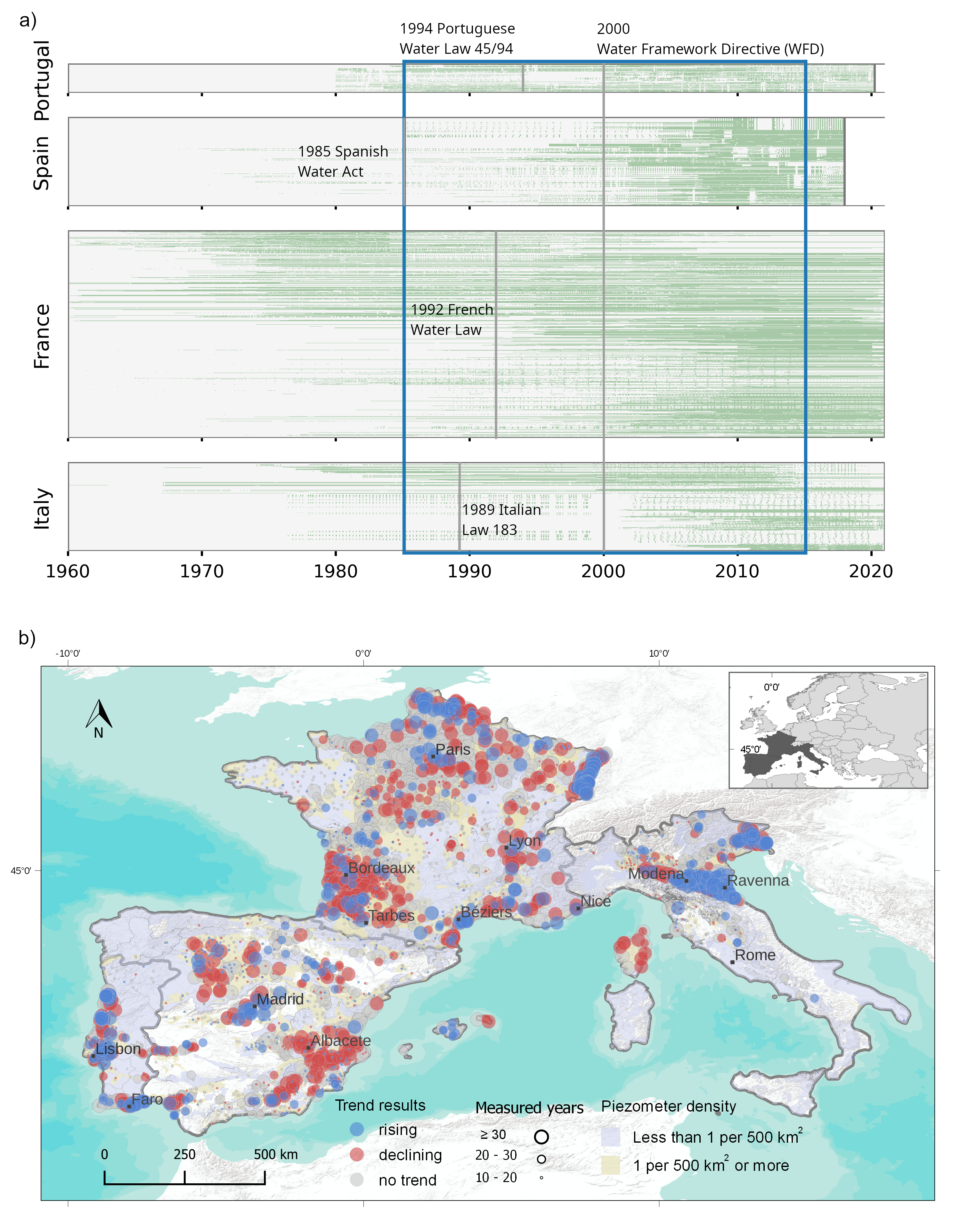
Our research, recently published in Nature’s Communications Earth and Environment, set out to provide the first regional-scale assessment of groundwater levels in this Mediterranean region. The goal was to understand long-term trends in groundwater levels and the climatic factors and human activities driving these changes. This work brings together data from 12,398 wells across the four countries, covering a period from 1960 to 2020. By combining this data with climate and land-use information, we aimed to comprehensively understand how groundwater resources are evolving under increasing water stress.
The Challenge of Collecting Regional Data
One of the primary challenges in this study was data collection. While we aimed to include as many countries as possible, the availability and accessibility of groundwater data were significant hurdles. Groundwater monitoring systems vary widely between countries, and in some, the data is fragmented and not easily accessible. For example, Spain, Portugal, and France have relatively centralized groundwater monitoring systems, but accessing and downloading large datasets was still challenging. Spain, in particular, lacked a bulk download system when we started our research, which made data collection slow and cumbersome. After our engagement, Spain has now included a section to download the entire database, a change that will benefit future research.
The challenge was even greater in Italy, where groundwater data is managed at the sub-national level. Our team had to contact local authorities across different regions, and even then, many datasets were incomplete or not digitized. Some records were only available in scanned or printed reports, making it impossible to analyze them systematically. These limitations in data availability highlight a broader issue: while groundwater plays an essential role in the region’s water supply, the systems for monitoring and sharing this data are not yet equipped to support large-scale, cross-border analyses.
Overcoming Obstacles and Building a Robust Dataset
Despite these obstacles, we succeeded in gathering data from over 12,000 wells, creating the most comprehensive groundwater dataset for southwestern Europe to date. The experience of gathering and harmonizing this data underscored the need for improved groundwater monitoring systems across the region. Systematic, easily accessible data is crucial for understanding groundwater trends and for making informed decisions about water use and conservation. In this regard, our work not only contributes to the scientific understanding of groundwater in southwestern Europe but also advocates for more robust monitoring and data-sharing practices.
What the Data Revealed: A Complex Picture
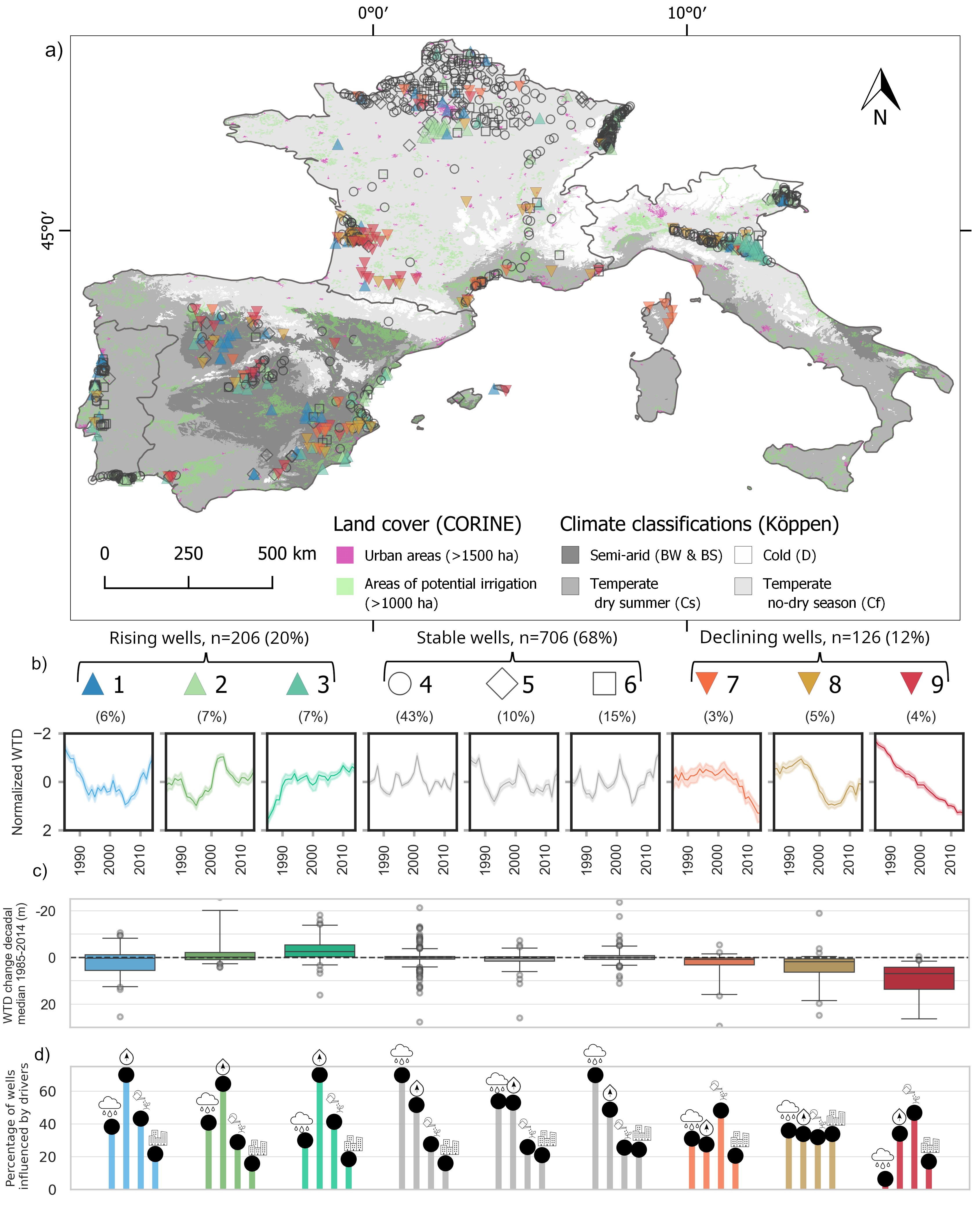
Contrary to expectations of widespread groundwater depletion due to droughts and agricultural demand, our analysis revealed a more nuanced reality. Of the wells we analyzed, 68% showed stable groundwater levels, 20% exhibited rising levels, and only 12% were in decline. This finding challenges the common perception that groundwater in the region is universally declining. Instead, we found a variety of patterns across different climates and regions.
Climatic and Human Drivers Behind Groundwater Changes
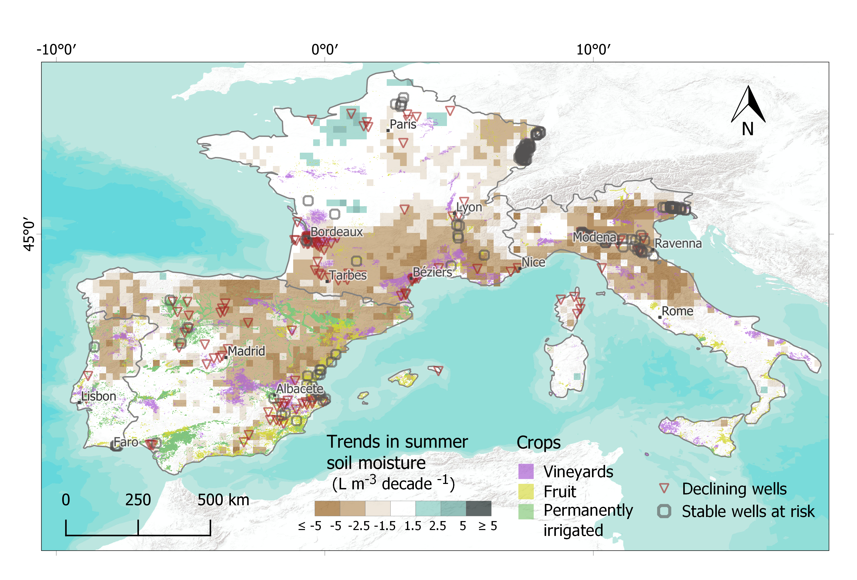
Our study explored the interactions between groundwater levels and both natural and anthropogenic factors. Precipitation, unsurprisingly, played a key role in areas where rising groundwater levels were observed. In temperate climates, regions that experienced higher-than-average rainfall over the last few decades saw groundwater recovery. On the other hand, regions where groundwater levels declined, such as agricultural areas in semi-arid climates, often faced prolonged soil moisture loss due to increased irrigation demands during hotter, drier summers.
Proximity to large urban areas also emerged as factor influencing groundwater trends. In regions such as southern France, groundwater declines were closely associated with the growing demand for domestic water supply in rapidly expanding urban areas. The city of Bordeaux, for example, has experienced significant groundwater depletion, driven partly by urban water use. This finding underscores the importance of managing groundwater not just for agricultural use, but also for urban water supply, particularly as cities in the region continue to grow.
The Importance of Systematic Monitoring
The insights from our study highlight the importance of long-term, systematic groundwater monitoring. As we’ve seen, groundwater dynamics are highly localized, with trends varying significantly even within the same region. Stable groundwater levels today do not guarantee stability in the future, especially as climate change and increased water demand put additional stress on these resources. Our study provides a benchmark for future assessments, showing that while some areas have stable or even rising groundwater levels, others are at significant risk of depletion.
Improving data collection and accessibility will be essential for sustainable groundwater management in the future. Our experience working with fragmented and incomplete data reinforces the need for centralized, cross-border monitoring systems. By improving access to data, we can better understand groundwater trends and make more informed decisions to protect this vital resource.
Looking Ahead
Our findings offer hope, but also a clear warning. While two-thirds of wells in our study showed stable groundwater levels, nearly a fifth of these are located in areas at risk of climate-induced declines. As agricultural droughts become more frequent and severe, especially in southern Europe, we could see significant shifts in groundwater dynamics. Without proactive monitoring and management, stable regions may quickly turn into areas of concern.
Groundwater is not just an invisible resource lying beneath the surface—it is a lifeline for millions of people. It plays a crucial role in sustaining ecosystems and economies across Europe. By deepening our understanding of how climate and human activities influence groundwater levels, we can develop better strategies for managing this critical resource in the face of future challenges.
References
1. Spinoni, J., Naumann, G. & Vogt, J. V. Pan-European seasonal trends and recent changes of drought frequency and severity. Glob. Planet. Change 148, 113–130 (2017).
2. Almendra-Martín, L. et al. Analysis of soil moisture trends in Europe using rank-based and empirical decomposition approaches. Glob. Planet. Change 215, 103868 (2022).
3. Masseroni, D. et al. The 63-year changes in annual streamflow volumes across Europe with a focus on the Mediterranean basin. Hydrol. Earth Syst. Sci. 25, 5589–5601 (2021).
4. Caloiero, T., Veltri, S., Caloiero, P. & Frustaci, F. Drought analysis in Europe and in the Mediterranean basin using the standardized precipitation index. Water 10, 1043 (2018)
5. De Stefano, L., Fornés, J. M., López-Geta, J. A. & Villarroya, F. Groundwater use in Spain: an overview in light of the EU Water Framework Directive. Int. J. Water Resour. Dev. 31, 640–656 (2015).
6. Maréchal, J.-C. & Rouillard, J. in Sustainable Groundwater Management A Comparative Analysis of French and Australian Policies and Implications to Other Countries (eds. Rinaudo, J.-D.,Holley, C., Barnett, S. & Montginoul, M.) 17–45 (Springer, 2020).
7. OECD. Drying Wells, Rising Stakes. https://www.oecd-ilibrary.org/agriculture-and-food/drying-wells-rising-stakes_9789264238701-en, https://doi.org/10.1787/9789264238701-en (2015).
8. Civita, M., Massarutto,A. & Seminara, G. Groundwater in the Southern Member States of the European Union: An Assessment of Current Knowledge and Future Prospects. Country Report for Italy. https://easac.eu/fileadmin/PDF_s/reports_statements/Italy_Groundwater_country_report.pdf (2010).
9. do Rosário de Jesus, M. Groundwater Protection for Public Water Supply in Portugal. https://unece.org/fileadmin/DAM/env/water/meetings/groundwater01/portugal.pdf (2001)
Follow the Topic
-
Communications Earth & Environment

An open access journal from Nature Portfolio that publishes high-quality research, reviews and commentary in the Earth, environmental and planetary sciences.
Related Collections
With Collections, you can get published faster and increase your visibility.
Archaeology & Environment
Publishing Model: Hybrid
Deadline: Mar 31, 2026
Drought
Publishing Model: Hybrid
Deadline: Mar 31, 2026




Please sign in or register for FREE
If you are a registered user on Research Communities by Springer Nature, please sign in