Transitioning from MODIS to VIIRS Global Water Reservoir Product
Published in Earth & Environment
Explore the Research

Transitioning from MODIS to VIIRS Global Water Reservoir Product - Scientific Data
Scientific Data - Transitioning from MODIS to VIIRS Global Water Reservoir Product
Reservoirs are indispensable for managing our water resources, playing pivotal roles in flood control, water supply, hydropower generation, and irrigation. Yet, the absence of continuous, long-term data—particularly acute in developing countries—poses significant challenges to effective water management. The strategic and geopolitical implications of reservoirs often result in restricted access to their data, underscoring the urgent need for transparent, universally accessible global reservoir datasets to improve water planning and management across various scales.
To bridge this data gap, satellite remote sensing provides continuous global observations of reservoir dynamics. Instruments such as altimeters—which measure water levels, combined with optical sensors like Landsat, the Moderate Resolution Imaging Spectroradiometer (MODIS), and the Visible Infrared Imaging Radiometer Suite (VIIRS)—all of which detect changes in surface area—are central to these efforts. Despite the improved technological capabilities of these instruments, there is still a fundamental gap in our knowledge about reservoir evaporation, a key factor in reservoir water budget amidst the challenges posed by climate change.
NASA's Global Water Reservoir (GWR) product, leveraging data from both MODIS and VIIRS, represents an important development by offering detailed insight into the dynamics of reservoirs (providing information about important reservoir metrics, such as surface area, elevation, storage, evaporation rate, and evaporation volume). It is the first operational, global-scale satellite product to provide both evaporation and storage data for 164 large reservoirs (151 man-made reservoirs and 13 regulated natural lakes). The total storage capacity of the 151 man-made reservoirs represents approximately 46% of the global capacity. Overall, this dual functionality of offering both evaporation and storage data empowers more comprehensive water security strategies.
MODIS has been the gold standard in global land monitoring for over two decades, renowned for both its data quality and its reliability. However, as MODIS nears the end of its operational lifespan, the transition to VIIRS marks a critical juncture in environmental monitoring. This move not only capitalizes on more advanced technology but also guarantees the continuity of land climate studies based on consistent data records from multiple sensors. NASA's dedication to ensuring data consistency across all land products—including the GWR—highlights the significance of this transition.
The importance of maintaining data continuity between the MODIS and VIIRS GWR products cannot be overstated. A smooth transition ensures that the extensive historical data collected by MODIS remains an asset for future research and policy formulation. This serves as a safeguard for the continued analysis of long-term trends, the evaluation of hydrological extremes (such as droughts), and the development of proactive strategies to address emerging water scarcity challenges.
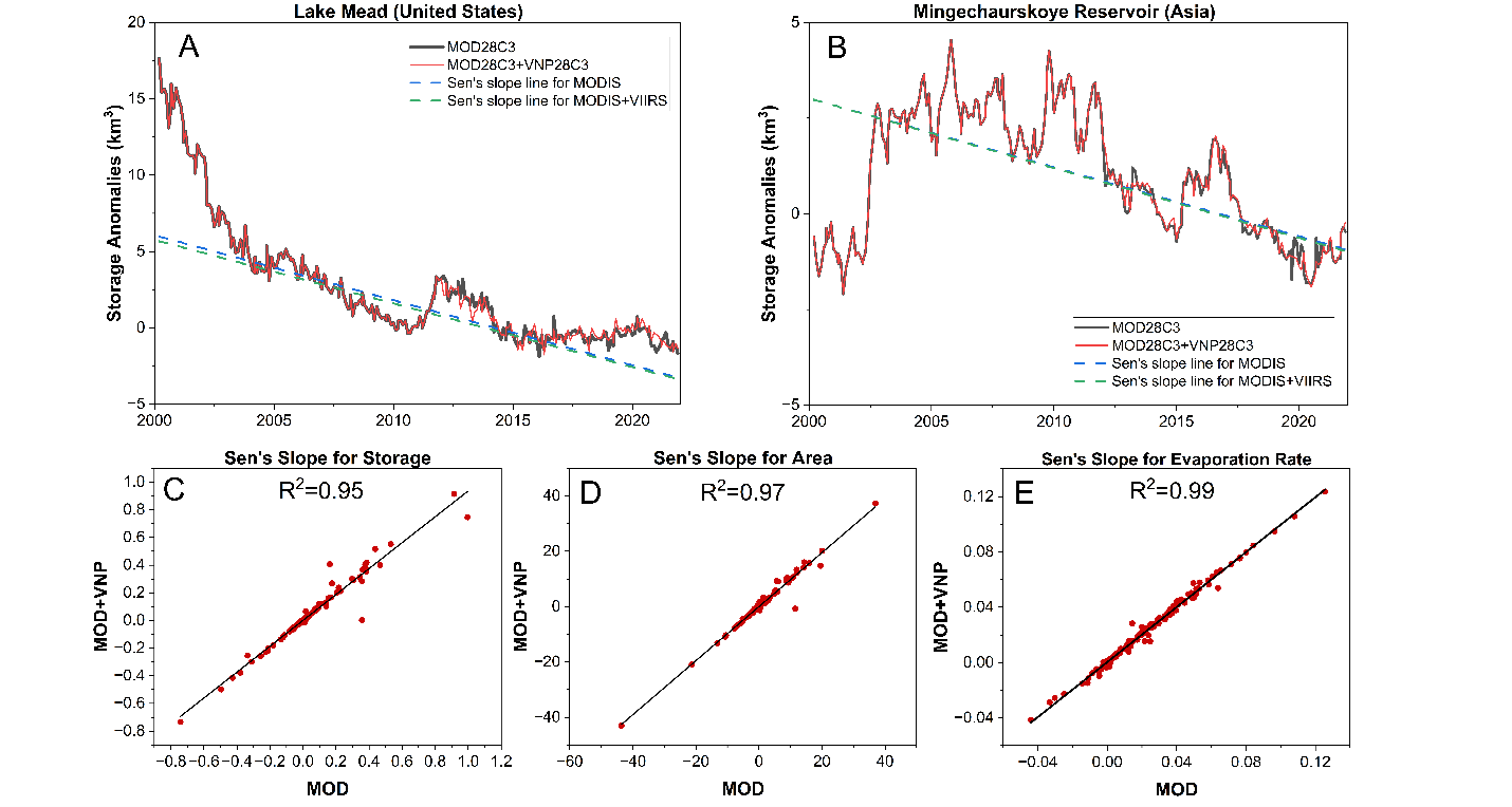
In this context, we have developed the VIIRS-based GWR, validated it against in-situ observations, and confirmed its continuity with MODIS across missions. Our analysis demonstrates a high degree of consistency between the VIIRS and MODIS GWR during their overlapping periods, with R² ≥ 0.90 and relative bias ranging up to ±15% across different variables. Furthermore, we have examined the possibility of sustaining the observed trends through the integration of VIIRS and MODIS data, with the goal of enabling a thorough analysis of long-term patterns beyond the retirement of MODIS (see Figure 1). Our results have revealed a strong agreement between the trends (Sen's slope) of MODIS and MODIS+VIIRS, as evidenced by high R² values (0.95 for storage, 0.97 for surface area, and 0.99 for evaporation rate). Overall, our study underscores the suitability of using VIIRS as a viable successor to MODIS, accurately capturing reservoir dynamics and ensuring data continuity.

Figure 1. Trend analysis of storage anomalies using the Mann‐Kendall and Sen's slope method for the period of 2012-2021 at (A) Lake Mead (North America) and (B) Mingechaurskoye reservoir (Asia). The black line shows the monthly storage anomalies from MOD28C3, the red line shows the combined monthly storage anomalies from MODIS (from 2000-2012) and VIIRS (from 2012- 2021), the blue dotted line shows the Sen's slope for MODIS, and the green dotted line shows the Sen's slope for the MODIS+VIIRS combined storage anomalies. (C-E) Comparison of the Sen's slope values between MODIS (MOD) and MODIS+VIIRS (MOD+VNP) for all 164 reservoirs with respect to (C) storage anomalies, (D) area anomalies, and (E) evaporation rate anomalies.
Video Credit: Terra/MODIS Land Discipline Team, NASA GSFC
Follow the Topic
-
Scientific Data

A peer-reviewed, open-access journal for descriptions of datasets, and research that advances the sharing and reuse of scientific data.
Related Collections
With Collections, you can get published faster and increase your visibility.
Data for crop management
Publishing Model: Open Access
Deadline: Apr 17, 2026
Data to support drug discovery
Publishing Model: Open Access
Deadline: Apr 22, 2026


Please sign in or register for FREE
If you are a registered user on Research Communities by Springer Nature, please sign in