Earth's Wandering Poles Impact Climate Over Geological Time
Published in Earth & Environment
The Backstory
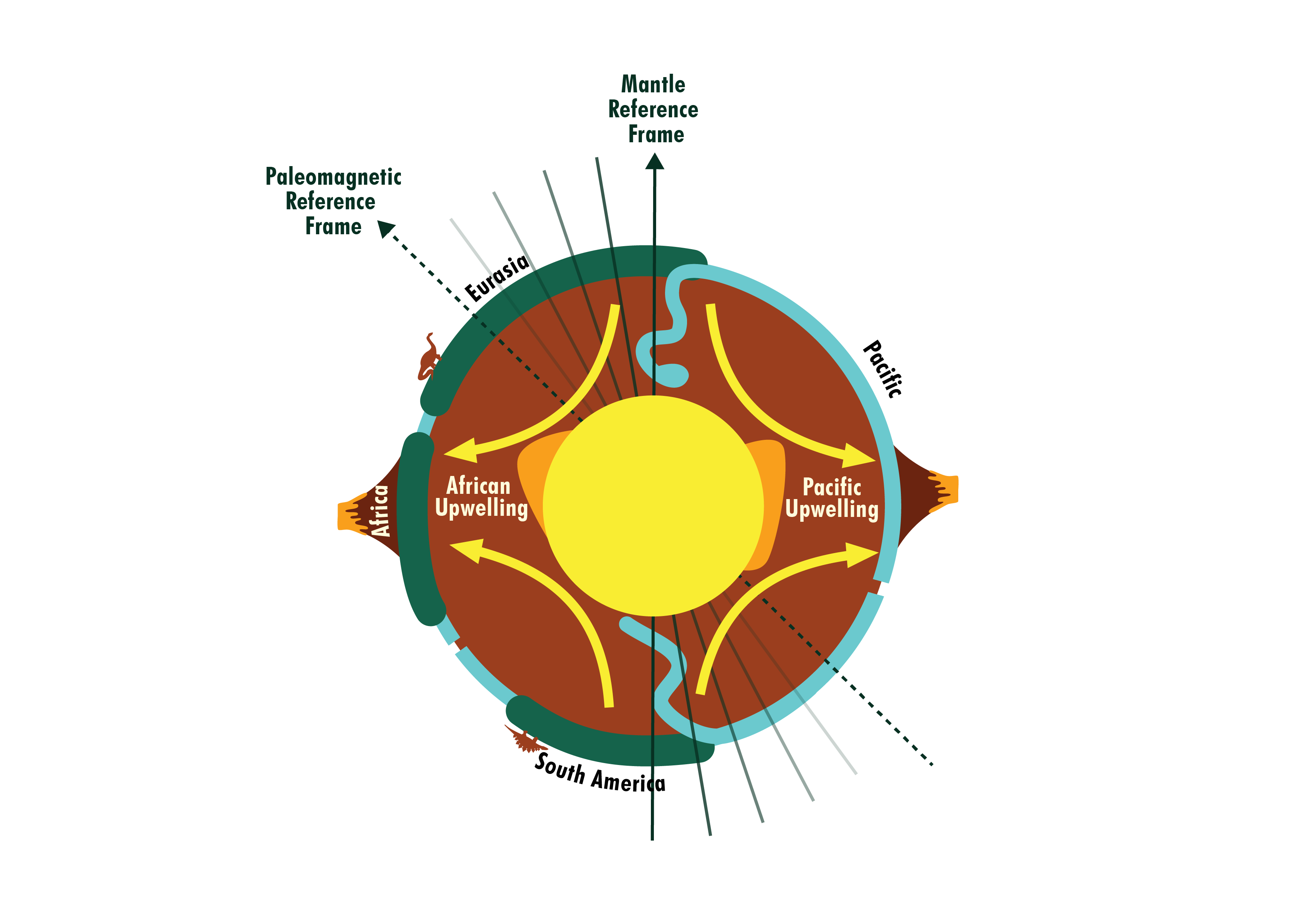
Have you heard of GPlates? If you study some aspect of the Earth further back in time than about the Miocene, chances are you have heard of it. For those that don't know, GPlates is powerful software that lets you reconstruct tectonic plates back through geological time, allowing anyone to figure out where things were and what the world looked like for their time period of interest. However, GPlates has a snag. The default plate reconstruction data that comes packaged with GPlates uses a thing called a 'mantle absolute reference frame'. Without going too far into the details, a mantle reference frame is where tectonic plates move relative to a stationary mantle. The reason for this comes down to the fact that absolute plate motions have traditionally been constrained using volcanic hotspot tracks that track mantle plumes as plates move over them. Taking hotspots and some other lines of evidence into account, we have a robust method of constraining the position of the plates in relation to the mantle. This is useful for keeping things simple in applications such as mantle dynamics, but unfortunately neglects a phenomena called True Polar Wander. This is essentially where the plates and the mantle together are moving relative to the core/spin axis, as illustrated below.

Because a mantle absolute reference frame doesn't take into account True Polar Wander, the absolute latitudes and longitudes given by a mantle reference frame will be off. While this is fine if we're focusing on the mantle, it becomes a problem when we study any part of the Earth's surface, where things like paleo-latitude matters are lot for paleoclimates. Luckily there's an alternative — a reference frame based only on rock paleomagnetic data that can record the true paleo-latitudes dictated by the Earth's magnetic field at the time of the rock's formation. While paleomagnetic data has issues (records can be sparse, error margins are often high, and they only record latitudes, not longitudes), they at least preserve true latitudes and therefore should be preferred when considering anything involving Earth's surface.
In our work at the University of Sydney on plate tectonic reconstructions, we noticed a lot of groups using a mantle reference frame. Some have good reason for this, but others would be better served with a pure paleomagnetic reference frame where true polar wander is accounted for. For this publication we worked with paleoclimate modellers from the Open University, UK to develop methods for quickly simulating climate over long time spans across the deep geological past. These climate models were then used to compare climate from a mantle vs pure plaeomagnetic reference from across the last 250 million years. We show that different reference frames can result in quite different regional climates, with average air temperature sometimes differing by as much as 20°C.

Why go through all the effort of working out a climate model?
While understanding the impact of reference frame choice is important, it wasn't the whole impetus for developing these climate model workflows. At the University of Sydney's School of Geosciences, we're attempting to understand the Earth through geological time by building a "digital Earth twin". This includes collaborating with ourselves and the broader Earth Science community to develop tectonic plate reconstructions, mantle convection models, landscape and geographic evolution models that are all interlinked. A missing piece of that puzzle was climate models, where they are particularly key to the formation and erosion of mountains and basins. This research originated in efforts to develop a climate model for use with our deep-time landscape evolution and plate tectonic modelling.
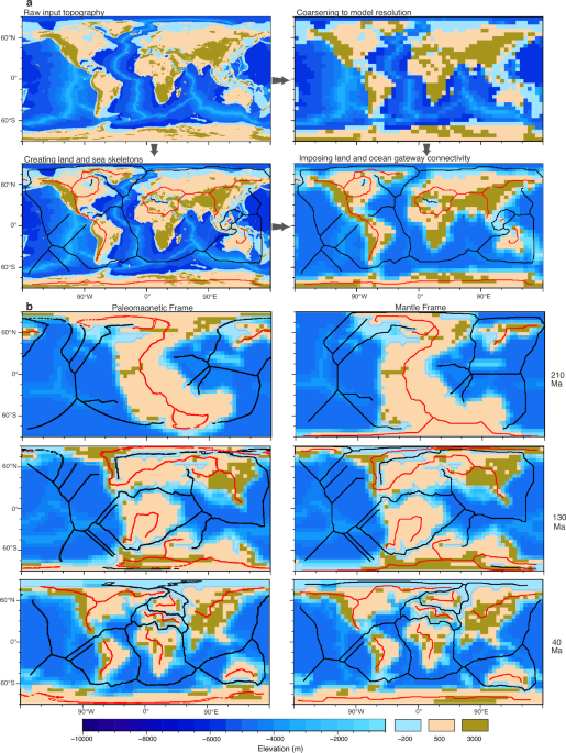
We eventually came across the right climate model for us — a coupling of the PlaSim atmosphere and GENIE ocean/vegetation/sea ice models (oddly called PLASIM-GENIE) that ticked all the boxes for working flexibly and efficiently but still performing well in terms of simulating climate accurately. We worked with Dr Philip Holden and Prof Neil Edwards at the Open University (UK) to implement this model across deep-time. New workflows were developed to convert paleogeographic configurations to model input files while preserving important things such as ocean gateways. In the end we had a new tool that let's us quickly get an idea of what past climate may have looked like with with different tectonic reconstructions.
Why look at polar wander?
After developing the tools for deep-time climate modeling, we decided that a comparison of reference frame was a suitable port of call to demonstrate something important while also showcasing the climate model. To demonstrate that choice of reference frame matters, we modeled climate across large swathes of time in both mantle and paleomagnetic frames. We compared not one but three mantle reference frames against two paleomagnetic reference frames for 10 million year snapshots from 250 Ma to the present. We also ran a study estimating the variation in simulated climate due to slight changes in coastlines, elevations etc. Overall we ran 181 different climate simulations. This would be a big undertaking using the 'traditional' deep-time climate models, but achievable with our new PLASIM-GENIE workflows. We found that the the climate does in fact differ depending on what reference frame is used.
What's next?
Among other things, climate models are useful for better understanding ancient life, where mineral deposits critical for Earth's energy transition may be lurking. We're currently using PLASIM-GENIE for looking at the emergence of Sclerectinian corals as well as helping find mineral resources in the Proterozoic. But we want these tools to be available to everyone. So from next year we plan to refactor the PLASIM-GENIE deep-time workflow code and release it freely to the broader public. We hope for this tool to be easy to use and accessible to anyone with basic coding competency. In the meantime, if you're interested in contributing or using it for your own research, please feel free to contact me.
Follow the Topic
-
Communications Earth & Environment
An open access journal from Nature Portfolio that publishes high-quality research, reviews and commentary in the Earth, environmental and planetary sciences.

Related Collections
With Collections, you can get published faster and increase your visibility.
Remote sensing and forests
Publishing Model: Hybrid
Deadline: Jul 31, 2026
Sustainable agricultural practices
Publishing Model: Open Access
Deadline: Jul 24, 2026


Please sign in or register for FREE
If you are a registered user on Research Communities by Springer Nature, please sign in