Landscape constrains drove the first peopling of Australia
Published in Social Sciences, Earth & Environment, and Arts & Humanities

First humans stepped into Sahul (the landmass connecting Australia along with New Guinea and Tasmania) devoid of any prior hominin species. Previous studies of this extraordinary feat of exploration have highlighted rapid post-arrival dispersal routes across the region. Some have favoured dispersal strategies in multiple directions simultaneously, others have suggested constrained routes along coastlines. Between those end-members, a series of most-likely dispersal scenarios and preferential pathways have been proposed and refined by incorporating the compounding influence of biogeographic, climatic, ecological, ethnographic, demographic and technological factors.
Reconstructing Sahul landscape at the time of first humans’ migration
One aspect that has been mostly overlooked when evaluating this spread of first humans across Sahul is the impact of climate-driven physiographic changes (the evolution of Earth’ surface geography) which took place during the time of migration. Yet, landscapes and landform features are deeply engraved in Aboriginal culture, highlighting the strong and long connections original inhabitants had and still have with the land.
In research published in Nature Communications, our interdisciplinary team (from The University of Sydney, Southern Cross University, Flinders University and Université Grenoble-Alpes) evaluates first Nations migration and occupation strategies by considering the evolution of the landscape during the time of dispersal.
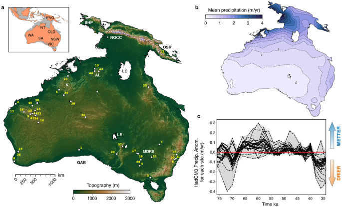
To do so, we take advantage of a recently developed landscape evolution model accounting for climatic evolution from 75,000 to 35,000 years ago and using already published high-resolution digital elevation model of Sahul. This allows for a more realistic description of the terrains and environments the first groups of hunter-gatherers live on when they first travelled across the region. More specifically, we use this model to estimate river catchments organization and changes in erosion and deposition patterns over time. Two processes known to influence the direction of dispersal as well as the timing of expansion. Combined with net primary productivity, these physiographic changes allow us to rank terrestrial habitats for their impact on human mobility.

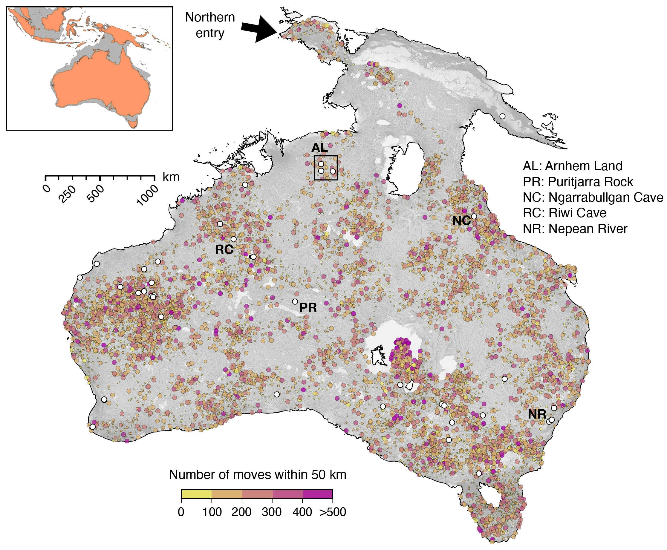
Results from one of our simulations showing predicted migration routes passing through 34 of the 40 archaeological sites older than 35,000 years (known archaeological sites corresponding to the white circles). Colours represent the number of moves between consecutive circles and the size of the circle is scaled based on the cumulative distance travelled by groups of hunter-gatherers.
Walking over a changing landscape
To examine the peopling of Sahul, we run thousands of mechanistic simulations (each describing a possible migration route see Figure below) on top of the evolving landscape. We consider two entry points: a northern route through West Papua (entry time: 73,000 years) and a southern one from the Timor Sea shelf (arrival time ~75,000 years). We then calculate the distribution of the produced routes and estimate the migration patterns and peopling speeds based on locations and ages of available archaeological sites. Our estimated migration speeds range between 0.36 and 1.15 km/yr. This range supports earlier estimates from stochastic-ecological models (0.71 to 0.92 km/yr) and recently published work (~0.4 km/yr); all suggesting a rapid peopling (in less than 10,000 years) across Sahul diverse ecological environments.
For both entry scenarios, our simulations predict high likelihood of occupation (>60%) in many of the iconic Australian archaeological sites distributed across the continent.
A wave of dispersal radiating across Sahul following rivers and coastlines
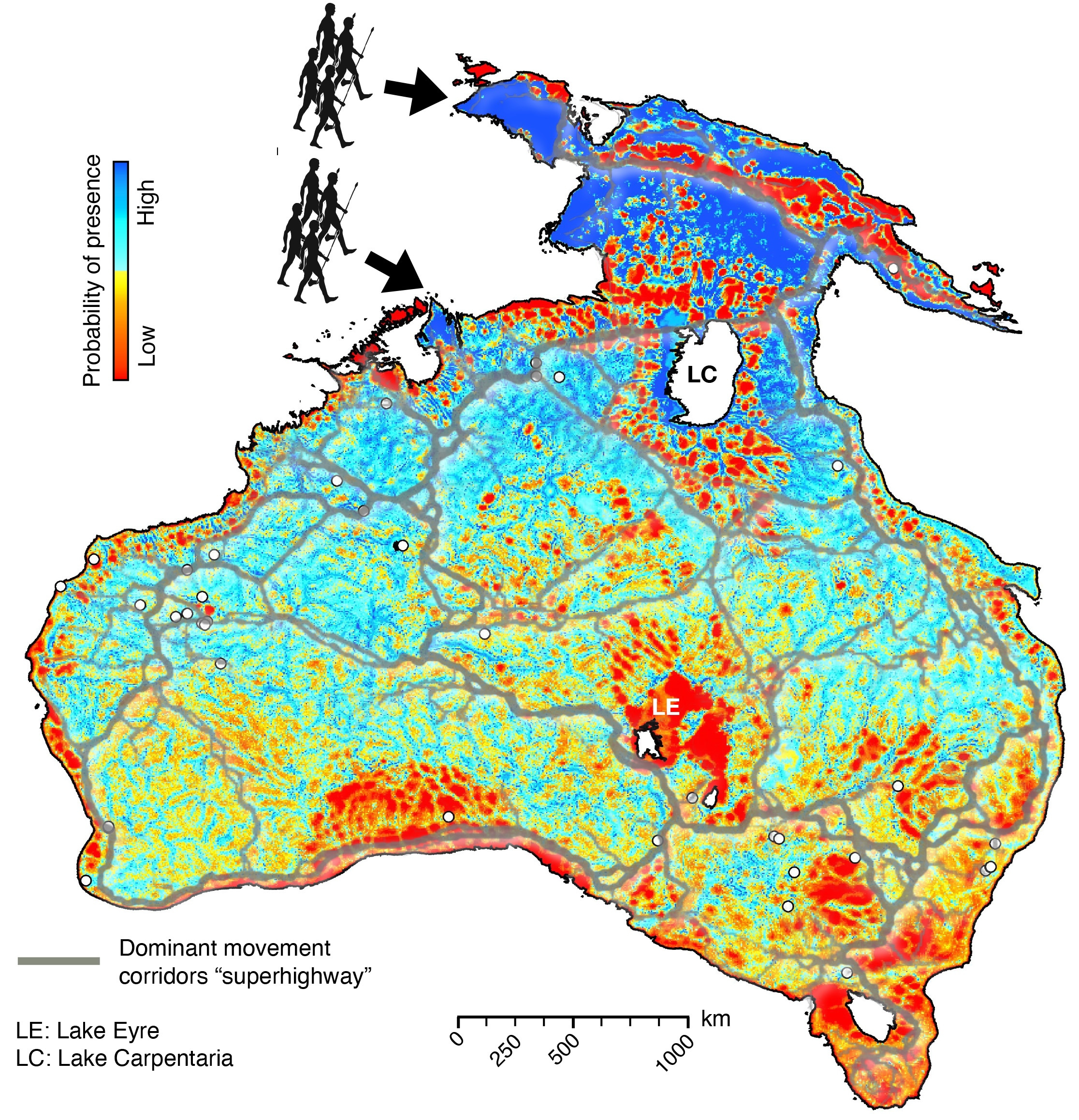
From predicted migration routes, we then produce a map of most likely visited regions across Sahul (probability of presence in the figure). We find that human settlers would have dispersed predominantly across the continental interior along rivers corridors on both sides of Lake Carpentaria, foraging following water streams with some high probability patches also present along receding coastlines. At the time of the first peopling, palaeoecological reconstructions show evidence of a strong diversity of interior habitats varying from high-altitude tropical forest, subtropical savannah, to semiarid woodland and grassland. The remarkable ability to adapt to these different ecosystems stands out as a key factor contributing to the global success of the human species.

Probability of human presence across Sahul by 35,000 years ago combining the northern and southern entry points. Cyan to blue areas correspond to regions with high probability of presence and red to yellow areas are regions which are never or rarely chosen. White circles indicate locations of archaeological sites. Grey lines overlaying the map show the dominant movement corridors interpreted super-highways of human migration across Sahul prior to 50 ka.
When compared to the super-highways model, we did not find well-defined routes (corresponding to the grey lines in the above Figure) and advocate instead for a radiating wave of migration. Yet our map shows that predicted presence is high in the vicinity of several of the proposed major corridors (east of Lake Carpentaria following the Great Dividing Range, southern corridors connecting Lake Eyre to the eastern corridors and the central super-highways transecting Australian arid interior).
An approach to aid future archaeological discoveries
An interesting outcome of the probability of human presence map is that it could be used in conjunction with the mechanistic simulations to evaluate how often a specific location is likely to have been visited. This could help to cost-effectively pinpoint areas of archaeological significance prior to an archaeological survey campaign. While our approach does not directly infer the preservation potential at a given location, the results from our landscape evolution model provide some clues on the amount of erosion and deposition experienced around the identified site.
Our study is the first to evaluate the impact of geomorphological changes on the initial peopling of Sahul. Combined with a human dispersal model, it suggests a wave of radiation that would favour the interior over coastal routes and a fast speed of migration. While its tempo is inferred from archaeological data, the mode of this initial peopling is not fitted to existing dataset in our approach and the high likelihood of occupation for dated archaeological sites brings confidence on the predictive capability of the method. Together with complementary studies, it provides a refined perspective on the Pleistocene archaeology of Sahul that could be applied to other regions to evaluate hominins mobility and their exceptional adaptation to changing environments. Ultimately improving our understanding of human’s extraordinary journey out of Africa.
Follow the Topic
-
Nature Communications

An open access, multidisciplinary journal dedicated to publishing high-quality research in all areas of the biological, health, physical, chemical and Earth sciences.
Related Collections
With Collections, you can get published faster and increase your visibility.
Women's Health
Publishing Model: Hybrid
Deadline: Ongoing
Advances in neurodegenerative diseases
Publishing Model: Hybrid
Deadline: Mar 24, 2026


Please sign in or register for FREE
If you are a registered user on Research Communities by Springer Nature, please sign in