Planning Future Reservoirs: A New Tool for Designing Low-Carbon Hydropower
Published in Earth & Environment, Sustainability, and Mathematical & Computational Engineering Applications
Rethinking “Clean” Hydropower
For a long time, hydropower was considered a low-carbon source of electricity, but over the last 15 years, studies have shown that reservoirs can be a major source of greenhouse gas emissions. When land is flooded to create a reservoir, the carbon cycle is fundamentally altered. Decomposing vegetation, organic matter carried from upstream watersheds, and algal growth within the reservoir all contribute to the production of carbon dioxide and methane. The magnitude of these emissions varies widely, depending on the site-specific conditions and reservoir operational practices.
The Intergovernmental Panel on Climate Change (IPCC) provides default emission factors for reservoirs, assigning the same values to all reservoirs within a given climate zone or at similar latitudes. It also reports hydropower’s median emission intensity of 24 gCO₂e (carbon dioxide equivalent) per kilowatt-hour. However, our work shows that these default values and median figures conceal a vast range of emissions, from near-zero in some reservoirs to levels higher than fossil fuel plants in others.
Most global and regional estimates of reservoir emissions still depend on these simplified emission factors or on data extrapolated from a few studied sites. The result is an incomplete picture of how reservoirs truly affect the planet’s carbon balance. As new hydropower projects are being developed around the globe, this gap in knowledge becomes even more pressing. We realized there’s a real need for better, more accurate tools that allow policymakers and developers to move beyond those simplified assumptions.
The Myanmar Challenge
We started developing a tool to help practitioners and researchers accurately measure not just emissions, but also the broader environmental impacts of reservoirs across entire regions. Myanmar provided the perfect test case for our new approach. The country’s diverse geography – from tropical coasts to northern highlands – produces large variations in temperature, rainfall, and vegetation, making it an ideal laboratory for studying how these factors affect emissions.
At the same time, Myanmar faces urgent infrastructure decisions: over 70 proposed hydropower projects totalling 25,865 MW, alongside growing demand for irrigation reservoirs to combat worsening droughts in the central dry zone. But these plans carry risks. Many proposed dams would affect the Irrawaddy and Salween rivers, two of the world's last major free-flowing rivers and biodiversity hotspots. Getting these decisions right – balancing energy needs, food security, and environmental protection while minimizing carbon emissions requires better tools.
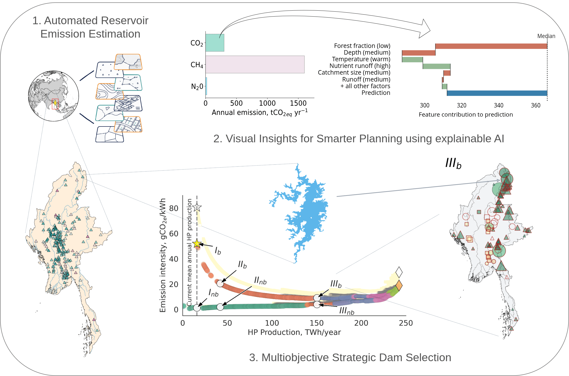
Our findings were striking. Emission intensities in Myanmar’s reservoirs ranged from less than 1 gCO₂e/kWh, similar to wind and solar, to more than 1,600 gCO₂e/kWh, higher than coal. A shallow, warm, lowland reservoir might emit over 5,000 gCO₂e/m2 each year, while a deep, mountain reservoir might emit less than 500 gCO₂e/m2. This variability shows that where we build reservoirs matters enormously. Yet most planning and feasibility studies still rely on simple “emission factors” by IPCC, if at all, and thereby miss these site-specific differences entirely.
Automation Meets Transparency
To make accurate emission assessments, we developed a new framework that combines three innovations.
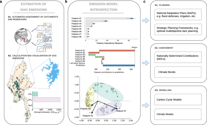
- First, we automated the process of collecting the input data required to estimate the emission footprint of reservoirs, following the modelling approach used in the GHG Reservoir (G-res) Tool. The G-res platform is based on empirical models derived from a large body of published research on reservoir emissions. It incorporates 37 environmental and physical variables — including temperature, rainfall, soil type, forest cover, reservoir depth, and catchment slope — to estimate net anthropogenic emissions. That is, it calculates the difference between what the reservoir emits and what the natural landscape would have emitted in its absence. Traditionally, gathering these inputs for each reservoir is time-consuming. Our open-source software, GeoCARET, addresses this challenge by connecting to Google Earth Engine to automatically analyse global spatial datasets. In about five minutes per dam, GeoCARET extracts all the required parameters and prepares them to use.
- Second, we developed a free, open-source implementation of the G-res model, enhanced with new modules for estimating CO₂, CH₄, and N₂O emissions. This software, RE-Emission, provides a unified framework for assessing all major reservoir-related greenhouse gases. When integrated with GeoCARET, RE-Emission enables a fully automated workflow for accurately estimating reservoir emissions at national or regional scales using spatially explicit models. Using RE-Emission, we created the most comprehensive reservoir emission model available for national- to regional-scale assessments.
- Finally, we made these complex models transparent using explainable artificial intelligence (xAI). We created visual ways of showing exactly which factors drive emissions at each site. For planners evaluating a potential dam, our breakdown plots reveal the story behind the numbers: "This reservoir has high emissions because it floods forested land in a warm, shallow valley with high nutrient runoff."

The Story the Numbers Tell
When we compared our detailed emission modelling framework to standard IPCC emission factors, the differences were substantial. Simplified emission factors overestimated Myanmar’s total reservoir emissions by about 50%, and for individual reservoirs, differences sometimes exceeded 200%. These differences have real consequences for planning decisions. When we used both methods to identify optimal low-carbon hydropower expansion strategies, they sometimes selected completely different sets of dams. The emission factor approach favored projects on the Shweli River, while the detailed model identified N’Mai River as a much lower-carbon alternative.
Our analysis revealed that Myanmar's current hydropower system has an average biogenic emission intensity of 52 gCO₂e/kWh, higher than the global median. Yet by incorporating emissions into planning from the start, the same energy output could have been achieved with just 3 gCO₂e/kWh by prioritizing run-of-river hydropower and carefully selected reservoir sites. That change would have eliminated nearly one million tonnes of CO₂e per year, conserved 239 km² of forest and farmland, and reduced river fragmentation— the damming and breaking apart of river systems that can block fish migrations and alter entire ecosystems.
Looking ahead
Our framework and tools are freely available as open-source software, ready to be applied anywhere. This matters because roughly 3,500 planned dams worldwide could add about 400 million tonnes of CO₂e each year - roughly 11% of the EU’s total emissions.
Reservoir planning will always involve trade-offs: energy, food security, flood protection, river health, biodiversity, greenhouse gas emissions, and others. But emissions can no longer be treated as an afterthought. With transparent, open and automated modelling tools, decision makers can now see and weigh these impacts alongside other priorities.
The opportunity is clear. We can design lower-carbon hydropower schemes by selecting deep, well-flushed reservoirs, avoiding carbon-rich forests in warm, shallow valleys. We can sequence dam construction to minimize cumulative impacts. Our tool doesn’t necessarily give all the answers, but helps ask better questions. That, ultimately, is the foundation of low carbon hydro infrastructure: decisions that are smarter, fairer, and better for both people and the planet.
Follow the Topic
-
Communications Earth & Environment
An open access journal from Nature Portfolio that publishes high-quality research, reviews and commentary in the Earth, environmental and planetary sciences.

What are SDG Topics?
An introduction to Sustainable Development Goals (SDGs) Topics and their role in highlighting sustainable development research.
Continue reading announcementRelated Collections
With Collections, you can get published faster and increase your visibility.
Hazards in Mountain Regions
Publishing Model: Open Access
Deadline: Nov 02, 2026
Ecosystems under marine heatwaves
Publishing Model: Hybrid
Deadline: Oct 22, 2026


Please sign in or register for FREE
If you are a registered user on Research Communities by Springer Nature, please sign in