Spatio-temporal assessment of potential nonpoint pollution risk sources in the Chavantes reservoir basin, Brazil
Published in Earth & Environment and Sustainability
Explore the Research

 elsevier.com
Just a moment...
Skip to main content
The relationship between human society and water is as old as civilization itself. But in the modern era, this relationship is under unprecedented strain. Uncontrolled urban growth and the relentless expansion of agriculture are fundamentally reshaping our landscapes. While these changes drive economies, they often leave a silent, creeping consequence in their wake: diffuse environmental pollution. Our latest research dives deep into this issue, using the vital Chavantes Reservoir basin in Brazil as a case study to model and understand this growing threat.
The problem is what scientists call non-point source (or diffuse) pollution. Unlike a factory pipe spewing waste into a river (a "point source"), diffuse pollution has no single origin. It’s the collective runoff from our daily lives: fertilizers and pesticides washed from vast fields of soy and sugarcane, oils from city streets, and sediment from deforested lands. When the rain comes, it carries this cocktail of contaminants across the watershed and into our rivers and reservoirs. Because it’s everywhere and nowhere at once, it’s incredibly difficult to measure and manage, yet it poses a significant risk to water quality and ecosystem health.
The Challenge: A Data-Scarce Environment
In many parts of Brazil, including the Chavantes basin, this challenge is compounded by a lack of frequent and reliable water quality monitoring data. Without this direct information, how can we possibly know which areas pose the greatest risk? How can we create effective management plans?
This is where geospatial modeling becomes an indispensable tool. Rather than relying on direct water samples, we can analyze the landscape itself to predict the potential for pollution. Our study aimed to do just that, creating a dynamic, spatiotemporal model to see how the risk of pollution in the Chavantes basin has changed over a critical 24-year period (1997-2021).
Our Approach: Building the Potential Non-Point Pollution Index (PNPI)
To quantify this risk, we developed a tailored Potential Non-Point Pollution Index (PNPI), adapting a methodology proven in other regions to the specific realities of Brazil. Our PNPI is a powerful analytical tool built on three key sub-indicators that, when combined, create a detailed map of pollution risk:
-
The Land Cover Indicator (LCI): This is the most critical component. It acknowledges a simple truth: not all land uses are created equal. A pristine forest acts as a natural filter, posing a very low risk. In contrast, an intensively farmed field of sugarcane or a dense urban area has a much higher potential to generate pollutants. Using data from MapBiomas, we assigned a risk coefficient to every type of land cover in the basin.
-
The Run-off Indicator (ROI): This indicator assesses how easily pollutants can travel across the land. It considers two main factors: soil permeability (how quickly water soaks in) and terrain slope. Less permeable soils (like dense clays) and steeper slopes lead to faster runoff, giving pollutants a direct highway to the nearest stream. Flatter terrain with porous soil, on the other hand, slows this process down, reducing the risk.
-
The Distance Indicator (DI): This accounts for the natural decay of pollutants. The further a pollutant has to travel to reach a water body, the more likely it is to be filtered or absorbed by the environment. Therefore, land closer to rivers and streams inherently poses a higher risk than land further away.
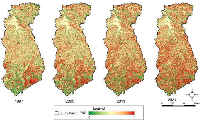
By integrating these three layers in ArcGIS Pro, we created a comprehensive PNPI map for the years 1997, 2005, 2013, and 2021, allowing us to see not just where the risks are, but how they have evolved over time in response to dramatic changes in land use.
What We Found: A Basin at a Tipping Point
The results of our analysis are stark. Over the two-and-a-half decades we studied, the Chavantes basin underwent a profound transformation. In 1997, the landscape was dominated by pastures (37.65%). By 2021, pastures had significantly declined, replaced by a massive expansion of annual crops (like soybeans and sugarcane) and, to a lesser extent, silviculture (timber plantations).
This shift in land use had a direct and measurable impact on the potential for pollution. Our model shows a clear and progressive increase in risk across the basin. While the average PNPI value for the basin still falls into the "Moderate Potential" category, the trend is deeply concerning.
The most alarming finding is the shift in risk distribution. In 1997, the basin was a mosaic of different risk levels. By 2021, the landscape had changed dramatically. The areas classified as Class IV (High Potential) and Class V (Very High Potential) for pollution now cover a combined 54.48% of the entire basin. In other words, more than half of the land feeding the Chavantes Reservoir is now in a high-risk state, a direct consequence of the intensification of agriculture.
Why This Matters and The Path Forward
Our findings confirm that Brazil's water resources are facing a growing threat that current management strategies may not be equipped to handle. Historically, the focus has been on controlling point-source pollution, such as improving sanitation. While vital, this is no longer enough. This study provides empirical evidence that diffuse pollution from agricultural expansion is a major, and accelerating, driver of environmental degradation.
This research underscores two urgent needs:
-
For Watershed Management: This PNPI model is more than an academic exercise; it's a practical tool for action. It allows policymakers and environmental agencies to identify critical pollution "hotspots" within a watershed. This enables targeted interventions, such as promoting more sustainable agricultural practices in high-risk areas or establishing buffer zones of native vegetation along waterways.
-
For the Scientific Community: Our model, while powerful, highlights a crucial area for improvement. The coefficients used for land cover and runoff are often based on expert opinion or studies from other countries. There is a critical need to develop and calibrate these indicators for Brazil's specific biomes and conditions through dedicated field and laboratory studies. This will make future models even more accurate and effective.
We welcome a broader discussion with fellow researchers, policymakers, and environmental managers on these findings. How can we better integrate geospatial tools into policy? And how can we work together to refine these methodologies to better protect our most precious resource: water?
PhD. Edinéia Aparecida dos Santos Galvanin holds a Bachelor’s degree in Mathematics, a Master’s degree, and a PhD in Cartographic Sciences, as well as a Habilitation (Livre-docência) in Applied Geoprocessing (2022), all from São Paulo State University (UNESP). She is currently an Associate Professor at UNESP, Ourinhos campus, and a permanent faculty member of the Graduate Program in Geography (Professional Master’s). She completed postdoctoral research in Geography at the Federal University of Rio de Janeiro (2015–2016) and in Spatial Statistics at the University of Minho, Portugal (2017). PhD. Galvanin coordinates the Research Group on Applied Geotechnologies for Environmental Studies. She is a member of the Remote Sensing, Research and Teaching in Geography Group at the State University of Mato Grosso. Currently, she serves as an alternate member of the Middle Paranapanema River Basin Committee (CBH-MP) and collaborates with researchers from the University of Minho and Universidad del Sur, Argentina. In 2024, she was a visiting researcher at Kansas State University, USA, through the Fulbright Research Program. Dr. Galvanin also serves as an ad hoc reviewer for national and international journals, including the reviewer board for the journal Remote Sensing. Her main research areas are geotechnologies, statistical modeling, and physical geography.
Follow the Topic
What are SDG Topics?
An introduction to Sustainable Development Goals (SDGs) Topics and their role in highlighting sustainable development research.
Continue reading announcement