Subducting slabs may be torn along plate joints in the ocean
Published in Earth & Environment
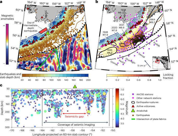
Subduction zones are responsible for the deadliest earthquakes and volcanic eruptions every year, making it critical for us to understand their structure and evolution over time. In the plate tectonics framework, they are the recycling factory of oceanic plates, where the subducting plate sinks into the mantle while volcanoes on the overriding plate generate new material. Subduction zones commonly display along-strike variations in earthquake density, locations, and magnitudes (Shillington et al., 2015), slab geometry (Hayes et al., 2012), or volcanic arc orientations. However, the drivers of these variations are highly debated. The Alaska-Aleutian subduction zone is a natural laboratory for investigating this topic thanks to its extent of more than 4,000 km from Alaska to easternmost Russia and notable variations of multiple observables. Specifically, along this margin, oceanic plate fabrics show complex patterns (Atwater, 1989), earthquake density, locations, and magnitudes change substantially (Shillington et al., 2015), the density, size, and orientation of the arc volcanoes vary, as well as the movement and deformation of the overriding plate is also heterogeneous (Elliott & Freymueller, 2020). These variations are particularly prominent in southwest Alaska, along the Alaska Peninsula, near Kodiak Island, and in the vicinity of Aniakchak Volcano and Mount Veniaminof. In this study, we investigated the driving mechanisms of the variations of subduction-related properties along the strike, and the role of the oceanic plate fabrics inherited from the spreading centers on subduction processes, including the geometry of the slab and the asthenospheric flow.
To address these points, we constructed a high-resolution 3-dimensional seismic velocity model using seismic tomography, in particular, a full-wave ambient noise tomography method. It is analogous to the Computer-Aided Tomography (CAT) scan in medical examination and allows one to see the inside of an object, the Earth in our case. In our seismic velocity model, at 100 km depth underneath Aniakchak volcano, we found that the relatively high seismic velocities delineating the subducting Pacific slab are imaged as much lower velocities than expected (Figure 1).

To understand the implications of this seismic observation, we compared our seismic velocity variations to other observations. For example, the low velocities in the region between Aniakchak volcano and Mount Veniaminof are spatially correlated with the along-strike location of a gap of earthquakes below ~150 km. Previously published seismic anisotropy results suggest that the mantle flows perpendicularly to the slab below the Aniakchak region, but parallel to the slab in other regions along the strike. Aniakchak volcano is also located near the intersection of oceanic plate fabrics in the Pacific plate, coming from two or more different spreading centers. We call this intersection of oceanic plate fabrics the “oceanic plate joint”. Based on these correlations, we interpret that the Pacific slab underneath Aniakchak volcano is tearing apart below ~150 km along a subducted “oceanic plate joint”. This slab tear allows the mantle to flow from underneath the plate into the overlying mantle wedge to feed Aniakchak volcano (Figure 2). The low velocities imaged in our model reflect the weakened slab at shallower depths, where subduction earthquakes are frequently observed.

This newly described process could have implications for subduction zones around the globe where oceanic plate joints are subducting (Figure 3). Our understanding of oceanic plate joints could be greatly improved with contributions from more seismic imaging, numerical modeling, and geochemistry analyses at global subduction zones and oceanic plates involving oceanic plate joints (Figure 3).

To read more about the topic, check out our article at the following link: https://www.nature.com/articles/s41561-025-01749-6
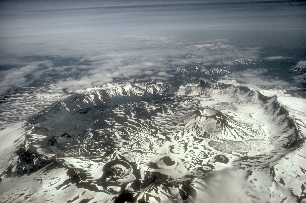
The poster photo was taken by M. Woodbridge Williams (National Park Service) and can be found at: https://volcano.si.edu/volcano.cfm?vn=312090
References:
- Atwater, T. Plate Tectonic History of the Northeast Pacific and Western North America (Geological Society of America, 1989); https://doi.org/10.1130/DNAG-GNA-N.21
- Elliott, J. & Freymueller, J. T. A block model of present-day kinematics of Alaska and western Canada. J. Geophys. Res.: Solid Earth 125, e2019JB018378 (2020).
- Hayes, G. P., Wald, D. J. & Johnson, R. L. Slab1.0: a three-dimensional model of global subduction zone geometries. J. Geophys. Res.: Solid Earth https://doi.org/10.1029/2011JB008524 (2012).
- Shillington, D. J. et al. Link between plate fabric, hydration and subduction zone seismicity in Alaska. Nat. Geosci. 8, 961–964 (2015).
Follow the Topic
-
Nature Geoscience
A monthly multi-disciplinary journal aimed at bringing together top-quality research across the entire spectrum of the Earth Sciences along with relevant work in related areas.

Related Collections
With Collections, you can get published faster and increase your visibility.
Drought
Publishing Model: Hybrid
Deadline: Jun 30, 2026
Tropical cyclones impacts and preparedness
Publishing Model: Hybrid
Deadline: Jun 30, 2026


Please sign in or register for FREE
If you are a registered user on Research Communities by Springer Nature, please sign in