The climatic pattern of East Asia shifted in response to cratonic thinning in the Early Cretaceous
Published in Earth & Environment
The serendipitous nature of research is among its most exciting aspects. In this study, the data were intended to test the phenomenon of fluid overpressure in ore-forming systems. However, the data yielded limited insights into fluid overpressure. This prompted us to explore what other geological processes might be inferred from the temporal and spatial distributions of the data.
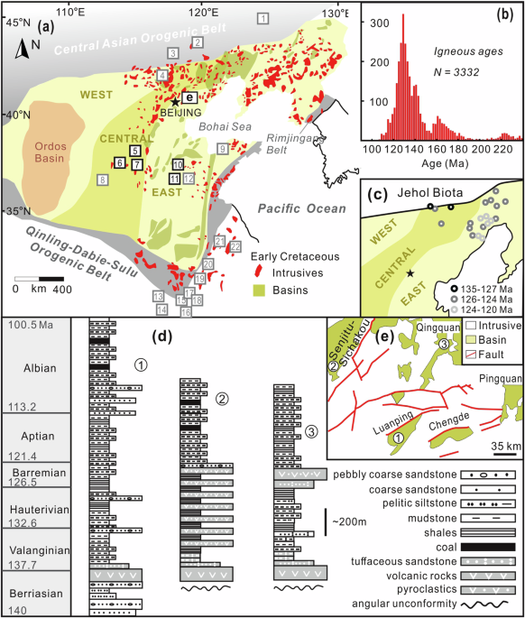
Skarn-type metal deposits typically form in relatively shallow environments, often less than 4 km deep. As a classic example of magmatic-hydrothermal deposits, skarn minerals are expected to capture information from both deep magmatic and shallow fluid sources. I collected a substantial amount of oxygen isotope data from garnet in skarn-type deposits within the North China Craton (NCC) during the Early Cretaceous. During this period, the NCC and its surrounding regions experienced widespread magmatic activity, leading to the formation of numerous magmatic-hydrothermal deposits and providing abundant samples for study. Surprisingly, when plotting the oxygen isotope data on a geological map, we observed anomalously low values in the northern NCC, whereas the southern, central, and eastern regions of the NCC exhibited significantly higher values.
What could explain this peculiar oxygen isotope distribution? The most plausible explanation is that the northern NCC had distinct fluid sources, probably linked to its back-arc tectonic setting during the Early Cretaceous. In this region, meteoric water likely participated in mineralization within a thin crust, leading to anomalously low garnet oxygen isotope values. In contrast, the thicker crust in other regions likely inhibited the influence of meteoric water, resulting in garnet oxygen isotope values that primarily reflected magmatic and metamorphic fluids.
To test this hypothesis, Prof. Xu Chu proposed calculating the crustal thickness of the NCC during the Early Cretaceous and analyzing magmatic data from the region. We compiled a comprehensive dataset, including major and trace elements, Nd isotopes, zircon trace elements, and Hf isotopes from intrusions associated with skarn garnet. The results supported our hypothesis: whole-rock [La/Yb]N and zircon Eu/Eu* ratios indicated that the crust in the northern NCC was significantly thinner than in other regions. This interpretation is further corroborated by Nd and Hf isotope data, which suggest a mantle contribution to crust formation in the northern NCC, while other regions were dominated by the reactivation of ancient crust.
While we established that the thin crust in the northern NCC allowed meteoric water to influence garnet oxygen isotopes, another critical question emerged: what caused the garnet oxygen isotope values to drop as low as –12‰? After extensive discussions with Xu, we hypothesized that the origin of meteoric water during this period held the key—it is plausible that precipitation in the northern NCC during the Early Cretaceous was sourced from the distant Tethys Ocean rather than the Paleo-Pacific. Moisture from the Tethys Ocean likely traveled along the westerlies, reaching the northern NCC and contributing to precipitation. This raised another question: why didn’t this moisture continue eastward over the Pacific Ocean, instead causing significant rainfall within the NCC hinterland? To address this, we turned to the tectonic evolution of the NCC during the Early Cretaceous and incorporated climate modeling to explore this phenomenon further.
From the onset of the Late Jurassic, westward subduction of the Paleo-Pacific Plate created a back-arc basin in the northern NCC under extensional tectonic conditions, while compression in the southern, central, and eastern NCC led to crustal thickening. A thickened crust would have formed elevated mountains or plateaus through isostatic adjustment, similar to the modern Andes. Although the “Eastern Plateau” hypothesis remains a topic of debate, there is little doubt that the NCC, influenced by Paleo-Pacific subduction, supported a coastal plateau or mountainous region. This elevated terrain likely acted as a barrier, blocking the eastward transport of moisture from the Tethys Ocean and redirecting it northward into the NCC hinterland.
To test this hypothesis, we reached out to Professor Jian Zhang from Peking University, an expert in climate modeling. Xu, Jian, and I held video conferences to discuss the modeling approach. One memorable meeting occurred on Lunar New Year’s Eve. While Xu and I, based in Toronto, were not immersed in the holiday atmosphere, Jian, located in Beijing, was preparing to celebrate the Spring Festival. We deeply appreciated his strong support and admired his dedication to research, even during the festive season.
A few days later, Jian’s climate simulation results were ready. The findings revealed that before the thinning of the NCC (when the coastal plateau was still present), moisture in East Asia primarily originated from the Tethys Ocean. A small fraction of Pacific-derived moisture also traveled along the northern edge of the plateau into the NCC hinterland. This long-distance transport resulted in significant oxygen isotope fractionation, progressively lowering the oxygen isotope values of meteoric water.
After the thinning of the NCC (when the coastal plateau subsided), the primary moisture source for East Asia shifted to the Pacific, with a sharp decline in contributions from the Tethys. The reduced transport distances associated with this shift led to less oxygen isotope fractionation. Notably, during this climatic transition driven by NCC thinning, the Jehol Biota in the northern NCC migrated eastward, following the shifting moisture gradient.
This study integrates insights from multiple disciplines, including tectonics, petrogenesis, metallogenesis, and paleoclimate. From an Earth system science perspective, this work highlights the interconnectedness of deep Earth processes and surface systems, illustrating how tectonic activity can reshape not only landscapes but also climatic patterns and ecological migrations. Understanding these links provides a framework for interpreting similar but exciting processes across other regions and geological periods.
Follow the Topic
-
Communications Earth & Environment
An open access journal from Nature Portfolio that publishes high-quality research, reviews and commentary in the Earth, environmental and planetary sciences.

Related Collections
With Collections, you can get published faster and increase your visibility.
Remote sensing and forests
Publishing Model: Hybrid
Deadline: Jul 31, 2026
Sustainable agricultural practices
Publishing Model: Open Access
Deadline: Jul 24, 2026


Please sign in or register for FREE
If you are a registered user on Research Communities by Springer Nature, please sign in