Where is all the water coming from?
Published in Earth & Environment
Our study started with a deceptively simple question: when it floods in Philadelphia, where is all the water coming from?
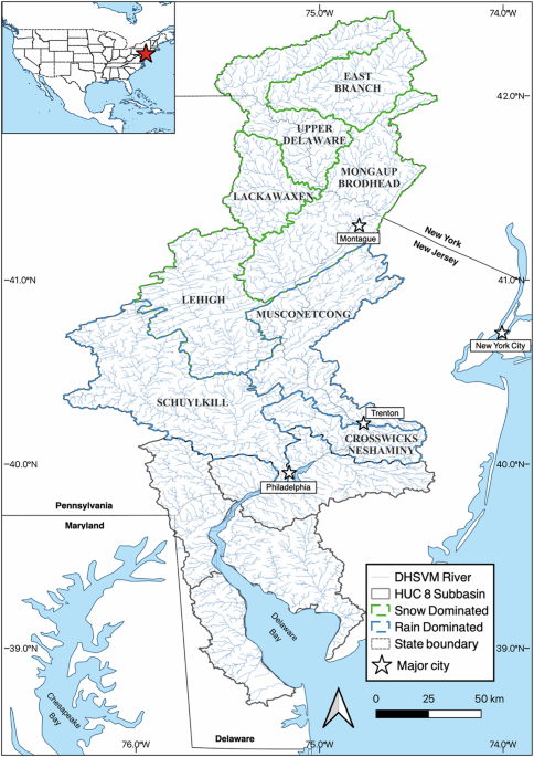
As hydrologists, we usually think in terms of watersheds—land areas that drain into a common outlet. So, we divided the Delaware River Basin, which feeds the river near Philadelphia, into distinct upstream “subbasins”. Our goal was to figure out which ones were responsible for generating floodwaters during major events.
To do that, we used a powerful new dataset that simulates how historical weather might have played out in a warmer future climate, like what’s expected by the late 21st century. We fed that data into a hydrologic model that simulates how rainfall and snowmelt travel over the landscape and into rivers. By looking at floods near the point where the Delaware River meets the estuary, we could trace their origins—at least in theory.
But here’s the catch: floods accumulate as you move downstream. That means any measurement at a subbasin outlet includes water from upstream subbasins, which makes it hard to say where the flood actually started. To get around that, we realized we’d need to simulate not just the whole river basin, but also isolate each subbasin on its own. That meant nine different model runs—one with all subbasins feeding water to the estuary, and eight more with only one subbasin active at a time.
What we found surprised us.
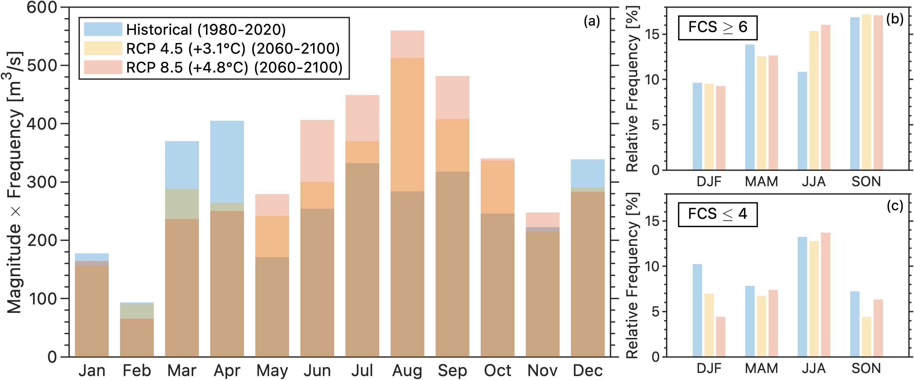
Most people—myself included—think of East Coast floods as a summer problem, driven by landfalling tropical storms. But our simulations showed that many historic floods were actually driven by snowmelt during late winter and spring. Growing up and studying hydrology in the western U.S., I learned how important snowmelt can be in places with big mountains and deep winter snowpacks. I never expected it to play a major role in a relatively low-elevation, coastal basin like the Delaware.
These snowmelt-driven floods were historically smaller but more frequent—a phenomenon sometimes referred to as “nuisance flooding”. Under warmer conditions, they grew significantly larger. Why? Because warming reduced snowpack, especially in the high-elevation tributaries. That meant more rainfall instead of snowfall during winter storms—producing faster runoff and stronger flood waves.
Even more interesting, we found that these upstream flood waves were becoming more synchronized with flood waves generated downstream. Like waves meeting in phase, they combined to produce larger downstream floods—a kind of “positive interference” effect. The end result: bigger, more dangerous floods near Philadelphia, not just because of one massive storm, but also because of the many tributaries peaking at the same time.
To test this further, we ran a second set of simulations where we only warmed one subbasin at a time while keeping the others in their historical climate. This let us isolate the effects of warming in each upstream area. Sure enough, when high-elevation, snow-dominated subbasins warmed up, synchronization with downstream areas increased. But when only the low-elevation, rain-dominated subbasins warmed, flood synchronization decreased. That confirmed the key role that snow loss plays in driving this emerging pattern.
But there was one more twist. While we observed larger and more synchronized floods during the cold season, these types of floods also became less frequent. The bigger concern turned out to be the summertime floods. These—often tied to tropical storms—grew not just larger, but also more frequent and more synchronized.
That finding was striking. It showed that warming isn’t just shifting the size of floods, but also the timing and dynamics of how floodwaters move through a landscape. The result is a shift in flood risk (which combines both the size and frequency of floods) from winter and spring toward summer and early fall. That means emergency planners, water managers, and communities may need to prepare for a very different flood season than the one we’ve historically planned around.
Our work highlights how understanding flood risk requires more than just looking at how much rain falls or how much snow melts. It’s also about when and where those processes occur—and how they align across space and time. In the case of the Delaware River Basin, a changing climate doesn’t just bring more water. It brings more coordinated water, which can be far more dangerous.
Follow the Topic
-
Communications Earth & Environment
An open access journal from Nature Portfolio that publishes high-quality research, reviews and commentary in the Earth, environmental and planetary sciences.

Related Collections
With Collections, you can get published faster and increase your visibility.
Remote sensing and forests
Publishing Model: Hybrid
Deadline: Jul 31, 2026
Sustainable agricultural practices
Publishing Model: Open Access
Deadline: Jul 24, 2026

Please sign in or register for FREE
If you are a registered user on Research Communities by Springer Nature, please sign in