Why interpreting mountain disasters is not straightforward
Published in Earth & Environment
Why getting the Dharali disaster right matters
When a disaster strikes in the mountains, the first explanations often arrive long before the science catches up. On 5 August 2025, a sudden and devastating mudflow struck Dharali, a small village in the Indian Himalaya. Within minutes, large parts of the settlement were destroyed, and more than 100 people were reported missing. Like many researchers working on mountain hazards, we followed the event as it unfolded, through satellite images, news updates, and eventually, eyewitness videos circulating online.
But for us, this was not just another case study. Many of us have spent years working in the Gangotri region, most recently as part of a UKRI NERC-funded project (https://gotw.nerc.ac.uk/list_full.asp?pcode=NE%2FZ503502%2F1) focused on understanding hazard processes in high-mountain environments. We have walked these valleys, studied their slopes, and interacted with the communities who live there. Dharali and the surrounding Harsil Valley are not just points on a map, they are places we know well, both scientifically and personally.
So when the disaster happened, it raised an immediate and urgent question: what exactly caused it?
Looking beyond first impressions
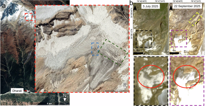
In the weeks and months following the event, different interpretations began to emerge. One of such explanations suggested that the disaster was triggered by an “ice-patch collapse”; a sudden failure of ice high up in the catchment. At first, this seemed plausible. High-mountain environments are complex, and cryospheric processes, those involving snow and ice, can play an important role in triggering hazards. But as we started examining the evidence more closely, we began to feel uneasy about this interpretation.
We went back to the data. Using the same satellite imagery, we carefully enhanced and re-examined the scenes, focusing on the area where the supposed collapse was reported. We compared pre- and post-event images, looked at the geometry of the terrain, and paid close attention to subtle surface features; things like crevasses, ice margins, and shadow patterns. At the same time, we considered other sources of information: field observations from the region, eyewitness accounts of multiple flows occurring within a short time window, and meteorological data showing persistent rainfall.
Slowly, a different picture began to emerge. Rather than clear evidence of a sudden ice collapse, the available observations suggested that the interpretation was far less certain than initially proposed. Features attributed to collapse could instead be explained by limitations in image quality, illumination conditions, and the inherent complexity of high-mountain terrain. This prompted us to more carefully examine whether alternative, non-cryospheric mechanisms, already well documented in similar environments, could plausibly explain the event without invoking ice failure.
Why this distinction matters
At one level, this might seem like a technical debate; ice versus rain, glacier versus sediment. But in hazard science, these distinctions are far from academic. How we explain a disaster shapes how we prepare for the next one.
If an event is attributed to glacier collapse, then monitoring efforts tend to focus on high-altitude ice bodies, looking for signs of instability. But if the same event is driven by persistent rainfall interacting with loose sediments, then the priorities shift: understanding rainfall thresholds, mapping vulnerable slopes, regulating construction, and improving early warning systems.
In Dharali, this distinction is particularly important. The village has seen rapid development in recent years, with hotels, homestays, and roads expanding into areas that are part of the natural debris-flow system. These are not static landscapes; they are dynamic, evolving, and inherently hazardous under the right conditions. Misidentifying the trigger risks misdirecting both science and policy.
The challenge of working with imperfect data
One of the things this work reminded us of is how difficult it can be to reconstruct events in remote mountain regions. Data are often incomplete. Satellite images may be obscured by clouds. Field access can be limited. Eyewitness accounts, while invaluable, can be fragmented. In Dharali, the first relatively clear satellite image became available more than a month after the event.
Under these conditions, it is tempting to draw conclusions from whatever data are available, especially when there is pressure to provide answers quickly. But this is precisely where caution is needed. A single satellite image, particularly one affected by poor illumination or cloud cover, can be misleading. Features can appear or disappear depending on lighting conditions. Shadows can mimic or obscure surface changes. Without careful validation, it is easy to misinterpret what we see.
This is why, in our Comment article (https://www.nature.com/articles/s44304-026-00211-w), we focused not just on proposing an alternative explanation, but on highlighting the uncertainties in the original interpretation and the importance of using multiple lines of evidence.
A responsibility to get it right
Writing this Comment was not something we took lightly. Scientific debate is a normal and healthy part of research, but in the context of recent disasters, where lives have been lost, it carries an added responsibility. Our aim was not to criticize for the sake of it, but to ensure that the explanation of this event is as robust and evidence-based as possible.
Because ultimately, this is not just about one paper. It is about how we, as a scientific community, approach complex and high-stakes problems. It is about how quickly we move from observation to interpretation. And it is about how those interpretations influence real-world decisions.
The risks of rushing
If there is one broader lesson from this experience, it is this: rushed interpretations of complex hazards can sometimes do more harm than good. In the immediate aftermath of a disaster, there is a natural urgency to explain what happened. But when conclusions are drawn from incomplete or ambiguous data, they can set narratives that persist and influence future research, policy, and public understanding. In regions like the Himalaya, where communities are already vulnerable and landscapes are rapidly changing, this matters enormously.
Looking ahead
The Dharali disaster is part of a growing pattern of extreme events in high-mountain regions, where climate change, geomorphic instability, and human activity are increasingly interacting. Through our ongoing work in the Gangotri region, we hope to contribute to a better understanding of these processes, not just in terms of what has happened, but in terms of what might happen next.
For us, this work is about more than publishing papers. It is about ensuring that the science we produce is careful, credible, and ultimately useful for the people who live in these landscapes.
Getting the story right is the first step.
Follow the Topic
-
npj Natural Hazards
npj Natural Hazards considers research examining the causes and effects of natural hazards, including seismic hazards, landslides and debris flows, volcanic hazards, coastal hazards, tsunamis, tropical cyclones and hurricanes, floods, droughts, extreme weather events, avalanche hazards etc.

Related Collections
With Collections, you can get published faster and increase your visibility.
AI for Natural Hazards
Publishing Model: Open Access
Deadline: Sep 30, 2026
Coastal Resilience
Publishing Model: Hybrid
Deadline: Mar 22, 2027
Please sign in or register for FREE
If you are a registered user on Research Communities by Springer Nature, please sign in