Can Earth Observation (EO) estimates of forest biomass aid climate policy?
Published in Earth & Environment, Sustainability, and Agricultural & Food Science
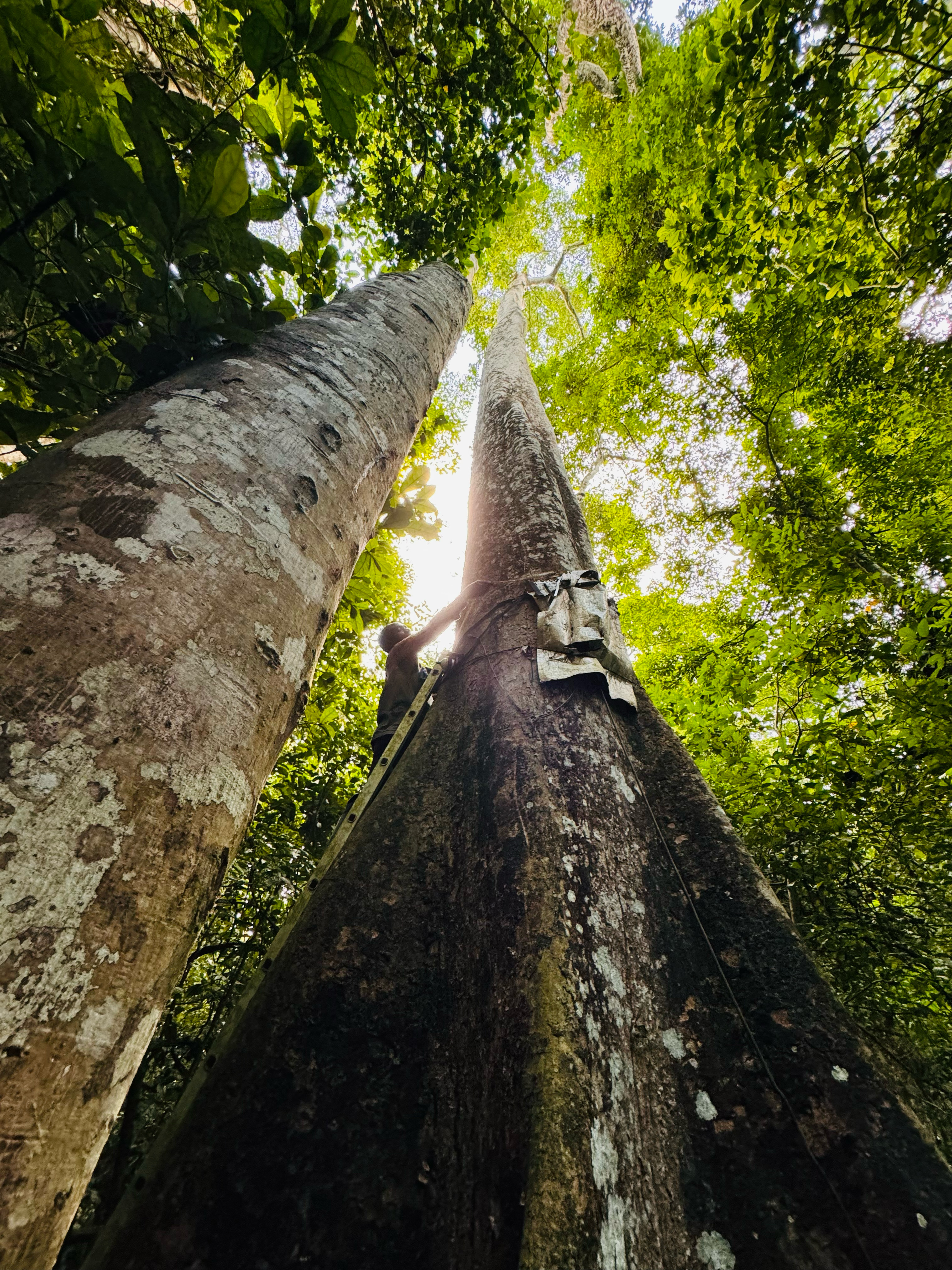
In the face of climate change, the need for precise and actionable data on forest biomass (roughly twice forest carbon) is increasingly pressing. By leveraging Earth Observation (EO) data — that is, data acquired from airborne and satellite sensors — scientists have been making open-source forest biomass estimates available for over a decade now. The vast geographical coverage of these data enables efficient and timely monitoring of forests in comparison to ground-based inventories. These may help countries monitor their forest resources, track changes over time and report their findings to international bodies, such as the United Nations Framework Convention on Climate Change (UNFCCC). Such assessments are important contributions to the Global Stocktake under the Paris Agreement, where nations assess collective progress toward climate goals. Yet, a recent synthesis of country reports has found a problematic science-policy gap: only a handful of countries use EO-based biomass maps in their assessments of forests and in policy-level reporting.
Working with the Biomass Harmonization activity under the Committee on Earth Observing Satellites (CEOS) Agriculture, Forestry and Other Land Use Roadmap, our study takes a first step toward filling this gap. It explores how EO-based biomass estimates - specifically those released by NASA’s GEDI and ICESat-2 missions, and ESA’s Climate Change Initiative (CCI) - may be presented in the format of Intergovernmental Panel on Climate Change (IPCC) policy guidelines on natural forests. This exercise, especially when continued in the future, enables such policy guidelines to be kept up-to-date with the latest space technologies and their data.
Developing a Framework for Forest Biomass Estimates
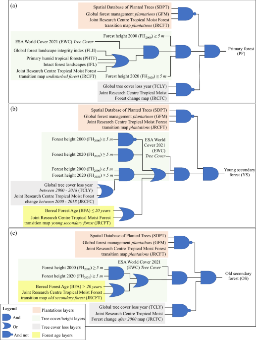
Countries lacking domestic data for (sub)national assessments of carbon stocks currently rely on IPCC's default Tier 1 values for natural forest aboveground biomass. These values are provided with an underlying stratification, dividing global forests by ecological zones, continents and forest status/condition, i.e. primary (intact old growth or with no active anthropogenic intervention), young secondary (≤ 20 years) and old secondary (>20 years) forests. For ease of integration into existing workflows of countries, our study first generates this stratification as geospatial layers by leveraging complementary strengths of numerous published datasets on global forests to date (as of 2024). It merges them using a Boolean scheme in a replicable, open-science framework. We prioritize flexibility and transparency, such that as any new datasets capturing ongoing biome shifts are released, they may be pulled in to improve our stratification of global forests.
Leveraging the Latest Space Technologies and Products
Once the IPCC’s global forest stratification is generated, the individual strata are populated with forest biomass estimates generated with data from space-based laser and radar sensors — NASA’s GEDI and ICESat-2, and JAXA’s ALOS-2 PALSAR-2 and ESA’s Sentinel-1A and -1B satellites that make the ESA CCI Biomass product. These data can be effectively utilized to estimate forest biomass because the laser sensors provide relatively high-resolution, three-dimensional measurements of forest canopy height and vertical structure, and the radar sensors are sensitive to vegetation structure, moisture and roughness. In contrast to the static snapshot of forest biomass, and especially if updated regularly, such EO-based datasets can reflect dynamic forest conditions and impacts of climate change on forest biomass with time. Our flexible methodological framework is designed to uptake forthcoming products from several planned EO missions, including ESA BIOMASS, NASA–ISRO Synthetic Aperture Radar (NISAR), and JAXA Multi-sensing Observation Lidar and Imager (MOLI).
Key findings on global forest status and biomass
For the year 2020, our study conservatively demarcates approximately 1678 Mha of primary forests, 1265 Mha of old secondary forests, and 316 Mha of young secondary forests globally. Tropical rainforests and boreal mountains/woodlands host the largest fractions of primary forests, while temperate and subtropical ecozones host most old secondary forests. The largest fractions of young secondary forests were found in tropical shrublands and rainforests, as well as subtropical humid forests. The trends in forest biomass across all strata are generally captured well by the EO-datasets; like the IPCC values, the EO-based biomass estimates indicate that primary Asian and African tropical rainforests and mountain systems harbor some of the highest forest biomass globally.
A Path Forward for EO-based forest assessments for policy
No research is without its limitations. Our focus was on replicating a prescriptive delineation of global natural forests that matches the classes in the IPCC Tier 1 defaults, and thereafter generate EO-based biomass estimates for the classes. Herein, the biggest challenges arose from the area mismatches between the various input datasets to stratify global forests, and the lack of datasets that specifically demarcate naturally disturbed areas, sparse vegetation or old secondary forests. The EO-based biomass estimates themselves have several limitations stemming from signal saturation or insufficient data to calibrate models.
As our understanding of global forests increases in the future, it is expected that geospatial layers classifying them into primary and young/old secondary forests will improve, as will their biomass estimates from space. Recognizing current limitations and building on our findings, we suggest two important steps as we go along into the future — (1) using independent ground (in situ) global datasets (e.g. GFBI or GEO-TREES) to validate EO-based forest biomass estimates, particularly targeting secondary forests and areas with disagreements between datasets, and (2) formulating supportive guidance for countries that will further permit and aid them in using EO-based forest biomass estimates in official policy-level reporting. With these steps, we anticipate that EO-based forest biomass maps will regularly provide a transparent, consistent and replicable picture of the state of the world’s forests, specifically relevant to global climate change policies and action.
Follow the Topic
-
Scientific Data
A peer-reviewed, open-access journal for descriptions of datasets, and research that advances the sharing and reuse of scientific data.

Related Collections
With Collections, you can get published faster and increase your visibility.
Computer vision in plant science and agriculture
Publishing Model: Open Access
Deadline: Oct 10, 2026
Wearable and Computer Vision Data for Health and Behaviour Research
Publishing Model: Open Access
Deadline: Aug 08, 2026


Please sign in or register for FREE
If you are a registered user on Research Communities by Springer Nature, please sign in