Exploring Human Mobility in Urban Nightlife: Insights from Foursquare Data
Published in Social Sciences and Earth & Environment
Explore the Research

 elsevier.com
Just a moment...
Skip to main content
Introduction
In today’s digital age, social media platforms like Foursquare provide a wealth of data that can reveal fascinating insights into human behavior, especially in urban environments. Our recent study, published in Cities, delves into how virtual mobility on Foursquare translates into actual human mobility in Tehran’s nightlife scenes. By analyzing user-generated data, we uncovered patterns that can help urban planners create more vibrant and functional nightlife spaces.
The Study at a Glance
Research Focus
Our study aimed to answer two key questions:
-
How does virtual mobility on Foursquare influence real-world human mobility in urban nightlife?
-
What spatial patterns emerge from these movements, and how can they inform urban planning?
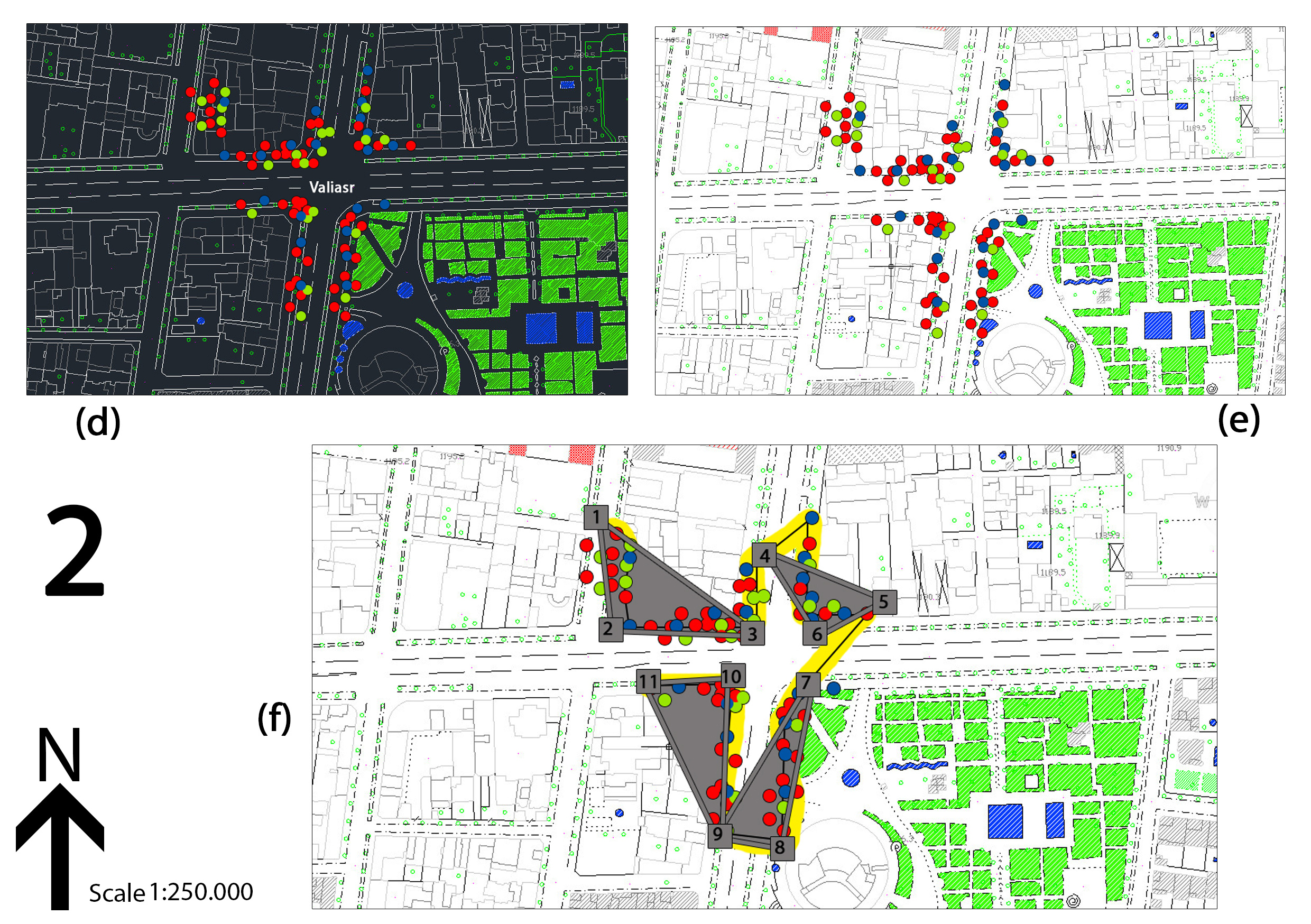
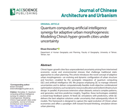
To explore these questions, we focused on two bustling nightlife spots in Tehran—Region 1 (Darband Square) and Region 6 (Valiasr crossroads)—where Foursquare data indicated high user activity.
Methodology
We combined data from two sources:
-
Foursquare API: To track user check-ins and identify popular nightlife venues.
-
Tehran Municipality API: To contextualize the data within the city’s urban framework.
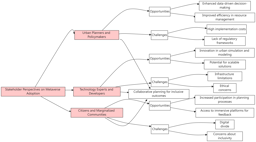
Using triangulation and interpolation techniques, we mapped the "human mobility triangles" in these areas, calculating the density and spread of user activity.
Key Findings
1. Hotspots of Nightlife Activity
-
Region 1 (Darband Square): A popular destination for occasional visitors (2–10 check-ins), with activity concentrated in the southern part of the square.
-
Region 6 (Valiasr crossroads): A hub for frequent visitors (10+ check-ins), showing higher density and more complex spatial patterns, including four distinct activity triangles.
2. Spatial Patterns
-
Smaller, tightly knit areas (like Valiasr’s triangles) had a more significant impact on nightlife dynamics than larger, dispersed ones.
-
Frequent visitors tended to cluster closer together, while occasional visitors maintained more distance, highlighting differences in mobility behavior.
3. Urban Planning Implications
-
Targeted Interventions: Planners can use these insights to enhance infrastructure, safety, and amenities in high-activity zones.
-
Global Applicability: Our method is replicable in other cities, especially in developing countries, to identify and optimize vibrant urban spaces.
Why This Matters
Understanding human mobility is crucial for creating cities that are not only functional but also lively and engaging. By leveraging social media data, urban planners can move beyond traditional surveys and tap into real-time, behavior-driven insights. Our study offers a scalable model for analyzing nightlife dynamics, paving the way for smarter urban policies.
Final Thoughts
This research bridges the gap between virtual and physical mobility, showcasing how digital footprints can shape better urban spaces. Whether you’re a planner, researcher, or simply curious about city life, our findings highlight the power of data in reimagining urban nightlife.
For more details, check out the full paper here (link to the article).
About the Authors:
-
Mahsa Najarsadeghi: Department of Urban Planning, Islamic Azad University, Tehran.
-
Ehsan Dorostkar: Department of Urban Planning, University of Guilan, Rasht.
Have thoughts or questions? Share them in the comments below!


Please sign in or register for FREE
If you are a registered user on Research Communities by Springer Nature, please sign in
Interesting work. It would be valuable to compare these findings with mobile phone or GPS-based mobility data to better assess the representativeness of social media-derived movement patterns.