How a Major Fault Shapes Anatolia's Landscape and Volcanoes
Published in Earth & Environment
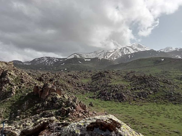
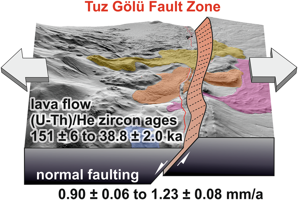
One of the most striking natural features visible from space, Tuz Gölü (Salt Lake), appears as a vast white expanse in the heart of Anatolia. Geologists have long recognized that its eastern boundary is not just a simple shoreline but a fault line—a fracture in the Earth's crust where movement occurs. Named after the lake, the Tuz Gölü Fault is a geological boundary that not only defines the lake’s eastern edge but also cuts through rock formations along a stretch of 200 kilometers. This includes lava flows from Hasandağ (Mount Hasan), a 3,253-meter-tall volcano located about 80 km southeast of the lake. These lava flows once descended the volcano's flank, but over time, they have been displaced by the fault, separating the downhill portions of the solidified lava from the craters where they originally erupted. Until now, however, scientists were uncertain whether the Tuz Gölü Fault caused the rocks on either side to slide past each other or move apart.
It was clear that the displaced lava rocks from Hasandağ held the key to solving this mystery. In May 2022, a team from Konya Technical University and Heidelberg University braved snowy weather to investigate further. With support from satellite imagery provided by team members at the University of Toronto, they ventured into remote areas of the volcano, visited only occasionally by shepherds and their intimidating guard dogs. By collecting volcanic rock samples from both sides of the fault, they aimed to match them like pieces of a puzzle that had been separated by past earthquakes.
An initial attempt to link lava rocks from both sides of the fault by studying their chemical composition in the lab failed because Hasandağ's eruptions had repeatedly tapped magma too similar to distinguish different lava flows. However, a breakthrough came from examining tiny zircon crystals within the lava. Using an ion microprobe at Curtin University to measure the radioactive decay products of uranium, researchers determined the age of the crystals. Over time, uranium decays into another radioactive isotope, 230-thorium, and by measuring the abundance of this isotope in zircon, they could establish when the crystals first formed in magma. Since the magma beneath the volcano continuously produced new zircon crystals, each lava flow carried zircon crystals with a unique 230-thorium age signature.
Once the lava flow segments were matched, the team analysed the same zircon crystals also at Curtin University to detect another uranium decay product: the isotope 4-helium. This allowed them to pinpoint when the lava flows originally erupted, which occurred between 151,000 and 38,800 years ago. Remote sensing data then helped measure how far the lava flow fragments had been displaced across the fault since their eruption. Using these measurements, the researchers calculated the fault's movement rate: about one millimeter per year. Importantly, they confirmed that the rocks on either side of the fault were moving away from each other, rather than sliding sideways. This distinguishes the Tuz Gölü Fault from the Northern and Eastern Anatolian Faults, which are notorious for their destructive earthquakes caused by rapid lateral movement of landmasses.
The study's findings have significant implications for understanding the geological forces shaping Central Anatolia. The movement along the Tuz Gölü Fault contributes to the region's gradual east-west stretching, differing from the dominant lateral shearing shown on most tectonic maps of Anatolia. By dating volcanic rock formations and reconstructing their displacement over thousands of years, the researchers demonstrated that the fault exhibits "pure dip-slip" movement—where rocky blocks move apart rather than grinding past one another. Understanding how faults move is essential for assessing earthquake hazards and the long-term evolution of landscapes. While the Tuz Gölü Fault is relatively slow-moving, these insights help geologists refine models of how the Anatolian plate behaves as it shifts between the colliding Arabian and Eurasian plates to the east and the extending Aegean region to the west.
Follow the Topic
-
Nature Communications
An open access, multidisciplinary journal dedicated to publishing high-quality research in all areas of the biological, health, physical, chemical and Earth sciences.

Related Collections
With Collections, you can get published faster and increase your visibility.
Women's Health
Publishing Model: Hybrid
Deadline: Ongoing
Biosensing
Publishing Model: Hybrid
Deadline: Sep 30, 2026

Please sign in or register for FREE
If you are a registered user on Research Communities by Springer Nature, please sign in