Mapping hydrothermal weakening at Vulcano
Published in Earth & Environment and Civil Engineering
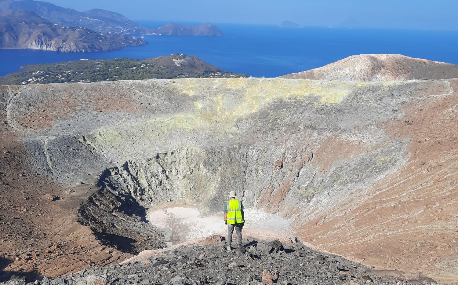

Hydrothermal alteration is widely recognized as a key process in weakening volcanic rocks, yet it remains difficult to account for in assessments of volcanic slope stability. Much of what we know about alteration-driven weakening comes either from laboratory experiments on a limited number of samples or from observations made after a collapse has already occurred. At Vulcano Island, altered ground is easy to identify at the surface, particularly around the fumarole fields and along the crater rim, but many of the most affected areas lie on steep, unstable flanks that are difficult or impossible to access safely. Standing on the crater rim (Fig. 1) , it was obvious where alteration was present, but far less clear whether those visual changes actually translated into mechanical weakness. Bleached or discolored surfaces are often assumed to be weak, yet appearance alone does not tell us how a rock will behave when stressed. This gap between what we can see and what we can measure motivated the study.
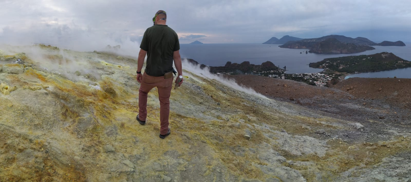
Fig.1: Collecting in situ rock-strength measurements on intensely hydrothermally altered material at the crater rim of La Fossa cone, Vulcano Island. This site represents one of the most altered zones on the volcano.
One of the hardest parts of the work was realizing that what looks altered from the air does not necessarily behave as weak rock. Drone imagery captures surface color and texture extremely well and allows us to map alteration patterns across the volcano, including areas that cannot be reached on foot. However, drone data alone cannot tell us how strong those rocks are. To address this, we spent long days in the field directly measuring rock strength, often on uneven ground, unstable slopes, or in areas affected by active degassing.
Previous studies have shown clear links between hydrothermal alteration and reduced rock strength, commonly associated with increased porosity and changes in mineralogy. However, these relationships are usually established either through laboratory measurements on small datasets or by inferring them from altered material found in landslide deposits after failure. What has been missing is a way to test whether surface expressions of alteration can be systematically linked to mechanical weakening across an entire volcanic edifice, particularly in regions that cannot be safely accessed.
What stood out to us was how consistent the relationship turned out to be. Even using simple, field-based strength measurements, rock strength decreased systematically with increasing alteration intensity (Fig.3). The weakest values were found in the most altered areas, many of which coincide with past landslides. Importantly, similar weakening was also observed on intact slopes that show no obvious signs of imminent failure, highlighting the potential for alteration-driven weakening to develop quietly over time.
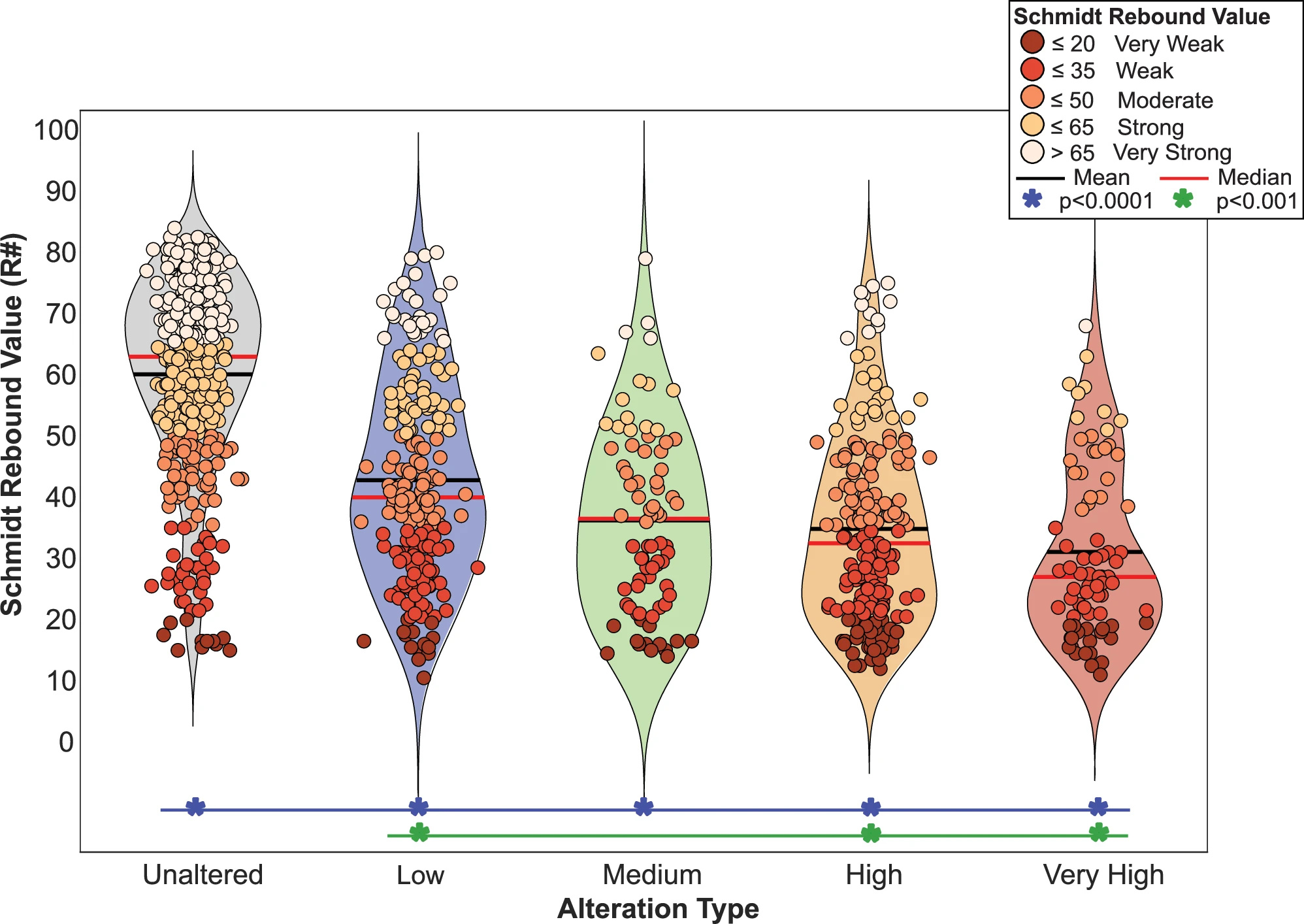
Fig. 2: The violin plot illustrates the Schmidt hammer rebound values distribution across different alteration types. The red line on each violin represents the median, while the black line indicates the mean. Data points (n = 1038) are color-coded by Schmidt rebound value, and the color of each violin corresponds to the alteration grades. The width of each violin reflects the density of measurements. To assess statistical significance, we applied a non-parametric Kruskal–Wallis test, followed by Bonferroni-corrected post hoc pairwise comparisons. Blue line and asterisks indicate pairwise comparisons significant at p < 0.0001, and green lines and asterisks denote comparisons with p < 0.001.
Beyond Vulcano, this work demonstrates how combining drone-based mapping with straightforward field measurements can help bridge the gap between surface observations and mechanical behavior. Linking surface alteration to rock strength provides a practical way to assess volcanic instability in difficult or hazardous terrain, where traditional sampling approaches are limited by access or safety. More broadly, this approach opens the door to tracking how hydrothermal alteration and mechanical weakening evolve through time, with implications for volcanic hazard assessment and monitoring at other active volcanoes worldwide.
Follow the Topic
-
Communications Earth & Environment
An open access journal from Nature Portfolio that publishes high-quality research, reviews and commentary in the Earth, environmental and planetary sciences.

Related Collections
With Collections, you can get published faster and increase your visibility.
Hazards in Mountain Regions
Publishing Model: Open Access
Deadline: Nov 02, 2026
Ecosystems under marine heatwaves
Publishing Model: Hybrid
Deadline: Oct 22, 2026

Please sign in or register for FREE
If you are a registered user on Research Communities by Springer Nature, please sign in