Moving beyond colorful maps: robust process-based crop modeling is needed for estimation of global food production potential
Published in Earth & Environment and Agricultural & Food Science
Global food demand must be met through substantial yield increases of major food crops on existing farmland to avoid massive cropland expansion at the expense of rainforests, wetlands and grasslands, and the rich biodiversity therein. Given limited farmland and water to support productive cropping, and uncertain global food supply chains due to increasing geopolitical tensions and pandemic, each country must assess the degree to which it can be self-sufficient in food crop production, and if not, where required imports can come from. Such evaluation requires information on yield potential, as determined by weather and soil properties, and yield gaps, which is the difference between yield potential and current farmer yields, which indicates the room that exists to increase food production on existing cropland. At issue, however, is how to best estimate yield potential and yield gaps?
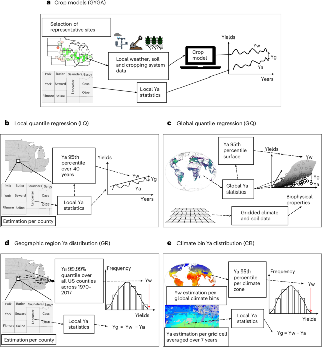
A growing number of studies seeking to estimate yield potential and gaps have relied on statistical methods. These studies determined yield potential based on the highest average yield, reported at a county, province, or state scale, and the resulting estimate of yield potential is extrapolated within the associated geographic region or area with similar biophysical conditions. Despite being widely used in the peer-reviewed literature, this methodology has never been evaluated for its capacity to estimate yield potential and current yield gaps.
Our study compared estimates of yield potential and yield gaps of major U.S. rainfed crops derived from four statistical models against those derived from a ‘bottom-up’ spatial scaling approach based on robust crop modeling and local weather and soil data. Process-based crop models used in this study have been rigorously validated for capacity to estimate yield potential based on experimental data from well-managed crops grown across a wide range of environments. We found that statistical methods failed to capture the spatial variation in yield potential, consistently under- or over-estimating yield gaps across regions. Moreover, statistical methods led to conflicting results, with production potential almost doubling from one method to another.
Why did statistical methods fail at estimating yield potential? One reason is that statistical methods lack a strong conceptual justification because they simply assume the highest average farm yields within a region represents the yield potential of that region. A second reason is that highest farm yield levels vary considerably from year to year within the same region due to differences in weather. Hence, yield potential may be grossly overestimate if based on highest farm yields during years with favorable weather. Likewise, some of the statistical methods extrapolate a single yield potential across large regions with a wide diversity of climates and soils that would support a similarly wide range in yield potential. In these cases, a detailed spatial analysis of soil and climate variation within a region is required as input to yield potential estimates and yet such supporting analyses are not performed.
Given these methodological challenges, it is not surprising that statistical methods do not provide reliable estimates of regional patterns in yield potential. It is thus a surprise that these untested methods have been used to estimate yield potential and determine food production potential in a number of prestigious journals, despite the lack of theoretical and empirical support to justify their use. This situation calls for a more rigorous review process and engagement of practitioners in the published literature on global food security and conservation of natural resources. The same applies to top-down approaches based on poorly-calibrated crop models and coarse gridded weather, soil, and management databases (Rattalino-Edreira et al. NFOOD 2021). On the other hand, the findings from our study emphasize the need to use well-validated crop models coupled with local soil and climate data, robust spatial frameworks and extrapolation methods to provide more reliable assessments of food production potential from local to regional and global scale. This approach gives reliable information across spatial scales that is needed to more effectively prioritize agricultural research & development (AR&D) investments, in both the public and private sectors.
It is the strong perception of the authors of the present study, and many colleagues in our agronomy community, that much of the peer-reviewed published science on food production capacity is based on methods that have not been validated at the appropriate scale, and our work shows that they give unreliable estimates. It is therefore essential to require adequate validation of methods across appropriate spatial scales in global assessments of crop production potential that are intended for use to guide policy dialogue and subsequent prioritization of AR&D investments.
Follow the Topic
-
Nature Food
This journal aims to provide researchers and policy-makers with a breadth of evidence and expert narratives on optimising and securing food systems for the future.

Related Collections
With Collections, you can get published faster and increase your visibility.
Ultra processed food and health
Publishing Model: Hybrid
Deadline: Dec 16, 2026

Please sign in or register for FREE
If you are a registered user on Research Communities by Springer Nature, please sign in