Over 200-years records of global urban dynamics reveal a greater than 40-fold increase in urban lands from 1870 to 2100
Published in Sustainability


Change of global urban extent is essential to evaluate the impacts of anthropogenic activities on natural and human environments. Rapid global urbanization has become a rising public concern due to its broad impacts on sustainability. Satellite observations are only available over past decades, limiting relevant studies about the urbanization impacts on global environmental change because the whole cycle of urban evolution always spans hundred years. A spatially explicit dataset of the global urban extent with a long temporal span is highly needed.
On September 29, 2021, our paper entitled “Global urban growth between 1870 and 2100 from integrated high resolution mapped data and urban dynamic modeling” was published in Communications Earth & Environment. In this work, we develop a modeling framework to hindcast and project global urban sprawl at a 1km resolution from 1870 to 2100 under five SSPs (Fig. 1). Using more than 20 years of satellite observations and the cellular automata model, we developed the first global urban extent product with more than 200 years of records.
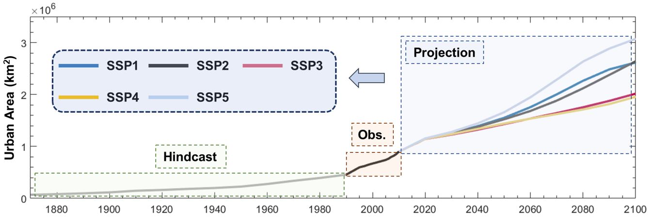
Fig.1. An overview of global urban extent dynamics from 1870 to 2100 under five SSPs.
Our results show that the global urban growth under SSP5 was the largest, with a greater than 40-fold increase in urban extent compared to 1870. By combing hindcast, projection, and remote sensing observations, we provided a continuous and consistent record of global urban dynamic spanning from 1870 to 2100 (Fig. 2). Our data of urban extents reveal pathways of urbanization across countries with diverse growth rates. Countries at different urbanization stages show unique urbanization patterns. This spatially explicit urban sprawl dataset provides insights into the life cycle of urbanization across different cities and is of great use to assess its impacts on long-term environmental changes and the human-environment interactions.
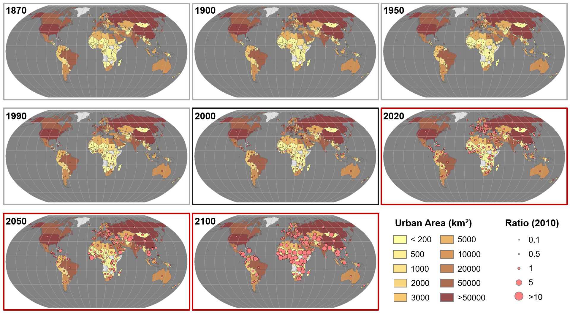
Fig. 2. Dynamics of urban extent at the country level in representative years relative to the base year of 2010. Hindcast: 1870, 1990, 1950, and 1990; Observation: 2000; Projection (SSP2: Middle of the Road): 2020, 2050, and 2100.
The integration of hindcast and projection of global urban dynamics can contribute to various studies relevant to urbanization. For example, such a long-term global urban extent dataset can be used as inputs to climate models to investigate the impacts of global urbanization (e.g., urban heat island) on global climate changes. Also, it can be a useful spatial proxy to explore the impact of urban expansion on habitat and biodiversity loss, particularly in those rapidly developing regions. Additionally, the long-term records of global urban extent dynamics can serve as essential inputs for improving the representation of urban dynamics in multisector human-Earth systems models.
References
Li, X., Y. Zhou, M. Hejazi, M. Wise, C. Vernon, G. Iyer & W. Chen (2021) Global urban growth between 1870 and 2100 from integrated high resolution mapped data and urban dynamic modeling. Communications Earth & Environment, 2, 201.
Zhou, Y., X. Li, G. R. Asrar, S. J. Smith & M. Imhoff (2018) A global record of annual urban dynamics (1992–2013) from nighttime lights. Remote Sensing of Environment, 219, 206-220.
Follow the Topic
-
Communications Earth & Environment
An open access journal from Nature Portfolio that publishes high-quality research, reviews and commentary in the Earth, environmental and planetary sciences.

What are SDG Topics?
An introduction to Sustainable Development Goals (SDGs) Topics and their role in highlighting sustainable development research.
Continue reading announcementRelated Collections
With Collections, you can get published faster and increase your visibility.
Remote sensing and forests
Publishing Model: Hybrid
Deadline: Jul 31, 2026
Sustainable agricultural practices
Publishing Model: Open Access
Deadline: Oct 31, 2026


Please sign in or register for FREE
If you are a registered user on Research Communities by Springer Nature, please sign in
Congratulations!