The uneven impact of climate change on drought with elevation in the Canary Islands
Published in Earth & Environment

Droughts are usually classified, according to their temporal extent, into meteorological (3-months), agricultural, hydrological (12-months), and socioeconomic. They are mainly associated with a reduction in precipitation, a deficit in soil moisture with a consequent impact on crops, a shortage of groundwater supply, and a failure of water resource systems to meet water demands, respectively. Here, we work with simulations driven by data from three global climate models in Project CMIP5 and two greenhouse gas emission pathways. The Canary Islands' topography requires simulations with a high spatial resolution (3x3km). Therefore, the projections were performed with high computational resources; 960 cores executing calculations for approximately one year.
Some extreme climatic phenomena, such as heat waves or droughts, are not defined globally but are calculated considering each territory's statistical characteristics. In the case of drought, the most commonly used indices fit the data to a probability distribution, which is subsequently normalized. A drought episode is considered to begin when the index is below the 16th percentile. This threshold is defined for the recent-past period and used to determine whether future precipitation and evapotranspiration conditions correspond to periods of drought, compared to current normal conditions.
To analyze droughts, working with indices that only consider precipitation can lead to erroneous conclusions in regions where evapotranspiration plays a critical role. Previous studies in the Canary Islands had already predicted a substantial increase in temperature with altitude, and the water vapor content in the atmosphere increases at a rate of 7% per 1ºC rise in temperature. Our projections also foresee a substantial decrease in precipitation accentuated with height, while evapotranspiration is expected to increase, which means less rain and more evaporation. The following figure shows the expected changes in four height intervals.

Annual cycle in precipitation (mm) and potential evapotranspiration (PET mm), for 30-year period simulations: recent-past (1980–2009) and future (2070–2099), CO2 emission scenarios RCP4.5 (intermediate) and 8.5 (high), at the four altitude intervals analyzed.
At low levels, evapotranspiration is significantly lower due to two factors. Firstly, low levels correspond mainly to coastal areas, where humidity increases, and the temperature remains mild. Secondly, due to the persistence of the thermal inversion, the almost permanent stratocumulus clouds located in the windward of the Canary Islands favor the reduction of incoming solar radiation.
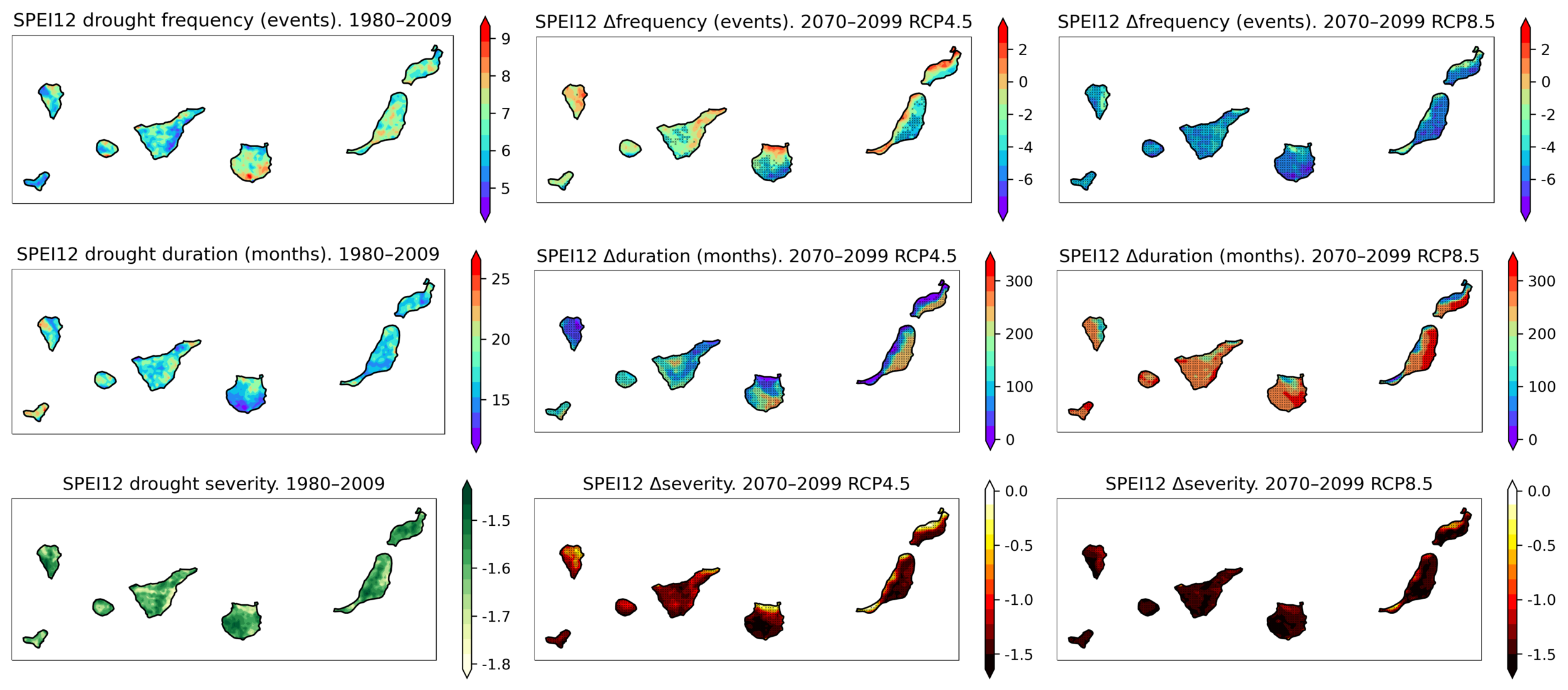
Our projections of the Standardized Precipitation-Evapotranspiration Index (SPEI) show a significant increase in the duration and severity of droughts by the end of the 21st century (2070–2099), relative to the recent-past (1980–2009), under intermediate and high emissions scenarios. The season with the most severe projected droughts is autumn, which may affect crop planting or reforestation management. An increase in the meteorological drought is also expected during the spring, affecting the growing season that can severely reduce crop yields. Additionally, the percentage of land affected by hydrological droughts, on average, would increase considerably, covering up to 96% in higher elevations in the business-as-usual scenario.

Drought frequency (number of drought events in 30 years) (1st row), duration (months) (2nd row), and severity (SPEI rating) (3rd row) for the SPEI index computed at a 12-month time scale. Changes in the frequency, duration, and severity of drought events for the future (2070–2099), under RCP4.5 (2nd column) and RCP 8.5 (3rd column), relative to the recent-past period (1980–2009) (1st column). Duration and severity were obtained from values averaged for the entire period, whereas frequency is the number of events in 30 years. Dotted grid points correspond to robust future changes.
Unlike droughts, aridity measures the long-term average water supply (precipitation) compared to average water demand (evapotranspiration). The aridity change index, ACI, indicates long-term climatic water deficits and is defined as the fractional change in potential evapotranspiration (PET) to the fractional change in precipitation (P).
Previous studies had calculated an ACI of up to 1.5 in the Canary Islands, identifying it as one of the archipelagos most affected by the increase in aridity. However, the simulations performed in this work, with increased spatial resolution, have allowed us to compute the ACI for each altitude interval. In the worst-case scenario, at high levels, represented in grey color in the following histograms, an aridity index of up 6 can be reached. Although general trends are in concordance, this difference in magnitudes may be due to the insufficient spatial resolution in those previous studies for the case of the Canary Islands.

Aridity change index (ACI) for 2070–2099 RCP 4.5 (left) and RCP 8.5 (right) expressed as histograms. The altitude ranges are indicated in the legend of histograms.
This work has contributed to filling the gap in high-resolution climate projections of drought in small islands and enabled the study of drought indices in the Canary Islands, where there are no previous works to the authors’ knowledge. Furthermore, the study has analyzed the uneven impact of altitude in drought, up to levels above 2100 m, which could be helpful in other regions of high altitudes.
Improving our understanding of the parameters affecting drought, their relationship, and their future projections is necessary to develop measures to reduce its impacts. Droughts will generally be considerably more prolonged and severe, worsening significantly with altitude.
Drought undoubtedly has a socio-economic impact on two vital sectors of the Canary Islands: tourism and agriculture, as well as their ecosystems. In addition, periods of drought increase the negative impacts of some hazards, such as fires. Particularly in the eastern islands, tourism development has boosted the installation of seawater desalination plants, despite the economic costs related to their energy demand. Desalination plants may continue to help mitigate the effects of drought on economic sectors at the expense of lower profitability, but ecosystems are more vulnerable to this hazard.
Follow the Topic
-
npj Climate and Atmospheric Science

This journal is dedicated to publishing research on topics such as climate dynamics and variability, weather and climate prediction, climate change, weather extremes, air pollution, atmospheric chemistry, the hydrological cycle and atmosphere-ocean and -land interactions.
Related Collections
With Collections, you can get published faster and increase your visibility.
Modeling of Airborne Composition and Concentrations
Publishing Model: Open Access
Deadline: Mar 31, 2026
Inter-Basin Dynamics: Cross-Ocean Interactions and Decadal Forecasting
Publishing Model: Open Access
Deadline: Apr 30, 2026


Please sign in or register for FREE
If you are a registered user on Research Communities by Springer Nature, please sign in