Looking for the origin of one of the largest Mediterranean tsunamigenic earthquakes : Amorgos, July 9th, 1956, Greece.
Published in Earth & Environment
For an earthquake to occur, a fault needs to slip and displace two blocks in different directions. When a large earthquake occurs, the fault usually slips and moves the two blocks apart, up to the surface, producing a trace at the Earth's surface. This trace, also called surface rupture, can run for a few to hundreds of kilometers along the fault, and it can offset the surface subtly or as a pluri-metric stair for instance. The size of these traces is proportional to the size of the earthquakes, and offsets at the surface are usually smaller than a few meters (not considering magnitude 9+ earthquakes, such as Sumatra 2004 or Japan 2011 earthquakes).
When large earthquakes occur offshore, the sudden displacements of the two blocks across the rupture fault may also displace the water column above and trigger a tsunami.
For past earthquakes, tsunami catalogs heavily rely on testimonies of coastal communities that have experienced these events, or on tsunami deposits found on land. These catalogs inform us on the geographical occurrence of tsunamis, but the exact sources of the tsunamis are elusive. This is especially true for historical tsunamis that were not, or incompletely, recorded by tide-gauges for instance. While earthquakes may be felt widely, seismic records may be scant or non-existent, and therefore their location is also uncertain. Therefore the location of the fault that slipped, offsetting the seafloor and potentially triggering the tsunami, is often unknown, or based on indirect inferences… until deep-sea vehicles are used for detailed seafloor mapping of these recently active faults.
Indeed, the seafloor is mainly unmapped, and when it is, the resolution of the data is, at best, 10 times larger than the traces left by an earthquake on the seafloor. It is like looking at a blurry landscape, where fault traces and earthquake ruptures are not in focus, and unidentifiable. With such data, looking for surface rupture is like looking for a needle in a haystack ! But with deep-sea submersibles, combining autonomous and remotely operated robots, we can sharpen this view, mapping the seafloor at different scales, and targeting in detail with images these ruptures - akin to observing the blurry landscape with the right glasses to sharpen it.
This is not the first time that marine geologists identified seismic ruptures on the sea bed with deep-sea vehicles. It has been achieved in the Caribbean and in Japan for recent earthquakes (2004 and 2011 respectively) that triggered tsunamis, and that are well located from seismic recordings. But here we searched for the rupture of an older and less documented submarine tsunamigenic earthquake, whose source remained enigmatic. Noteworthy, it produced the largest tsunami of the past 2 centuries in the Mediterranean Sea. This happened in 1956, about 66 prior to our discovery.
The Amorgos earthquake occurred on July 9th, 1956, between Amorgos and Santorini island in Greece. Poorly constrained, , its magnitude likely ranged between 7.2 and 7.8, a particularly high for the Mediterranean Sea. It was felt in Türkiye several hundreds of kilometers away from its origin. Its exact location and depth has been the subject of debate as only a few seismometers were installed at that time. It occurred early in the morning, and was followed 13 minutes later by a second earthquake, closer to Santorini. Both shocks damaged the archipelago, and especially Santorini islands, leading to 53 casualties.
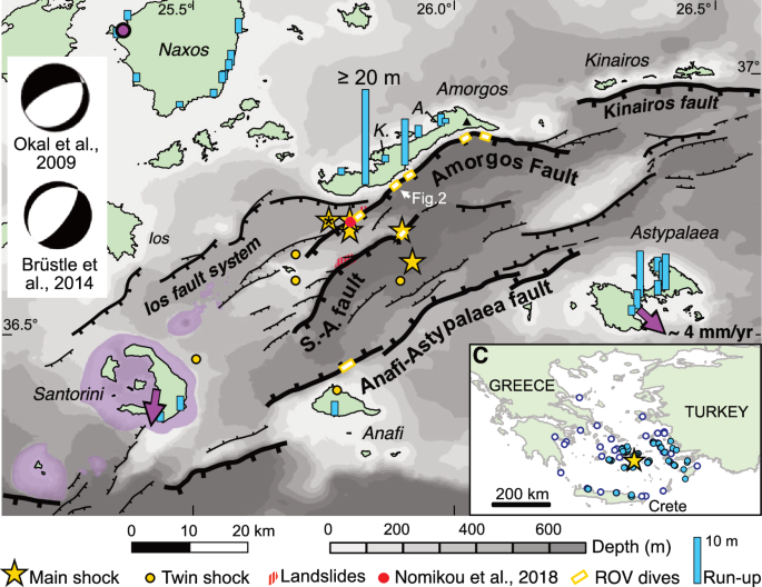
A few minutes after the first shock, a tsunami flooded most of the nearby coastlines with waves a few meters high. Two shepherds perched on the cliffs along the southern coast of Amorgos island witnessed a wave particularly high, at least 20 m high. A few kilometers from there, along the southeastern coast of Amorgos, the tsunami reached a height of ~10 m. Fishermen that we met and that were kids at that time, told us that on the other side of the islands, Amorgians were able to cross by foot shallow bays where the sea had retreated. Facing Amorgos, the island of Astypalaea was also flooded with 10 m high waves locally.
This major event for the Mediterranean Sea was left with no identified earthquake and tsunami sources. The origin of the tsunami has also been discussed, and attributed not only to the earthquake, but also to submarine landslides triggered by it. The offshore faults potentially hosting this earthquake were unknown at that time. An international cruise in 2015 mapped the seafloor in between Santorini and Amorgos, revealing three main faults lying ~700 m below sea level; all of them were likely candidates for the 1956 earthquake and tsunami.
Since 2022, our international team, composed of members of Géoazur-Université Côte d’Azur, Institut de Physique du Globe de Paris, National and Kapodistrian University of Athens, Géology laboratory of École Normale Supérieur de Paris, et Vicorob laboratory from Girona University, set out to constrain the source of these major events.
In April 2022, we boarded the Research Vessel (R/V) Europe of the French Oceanographic Fleet, departing from Heraklion in Crete. The vessel was carrying the autonomous deep-sea vehicle AUV IdefX. This vehicle can dive and fly close to the seafloor, mapping its shape with a resolution better than 1 m. During 3 weeks with bad weather, strong wind, and a few nice days, we worked offshore the Aegean archipelago to launch and follow IdefX during its flights over the three main faults. While unprecedented in resolution and clearly revealing the fault scarps, the data were insufficient to unequivocally identify the ruptured fault. For a year, we studied these data, and prepared our next mission.

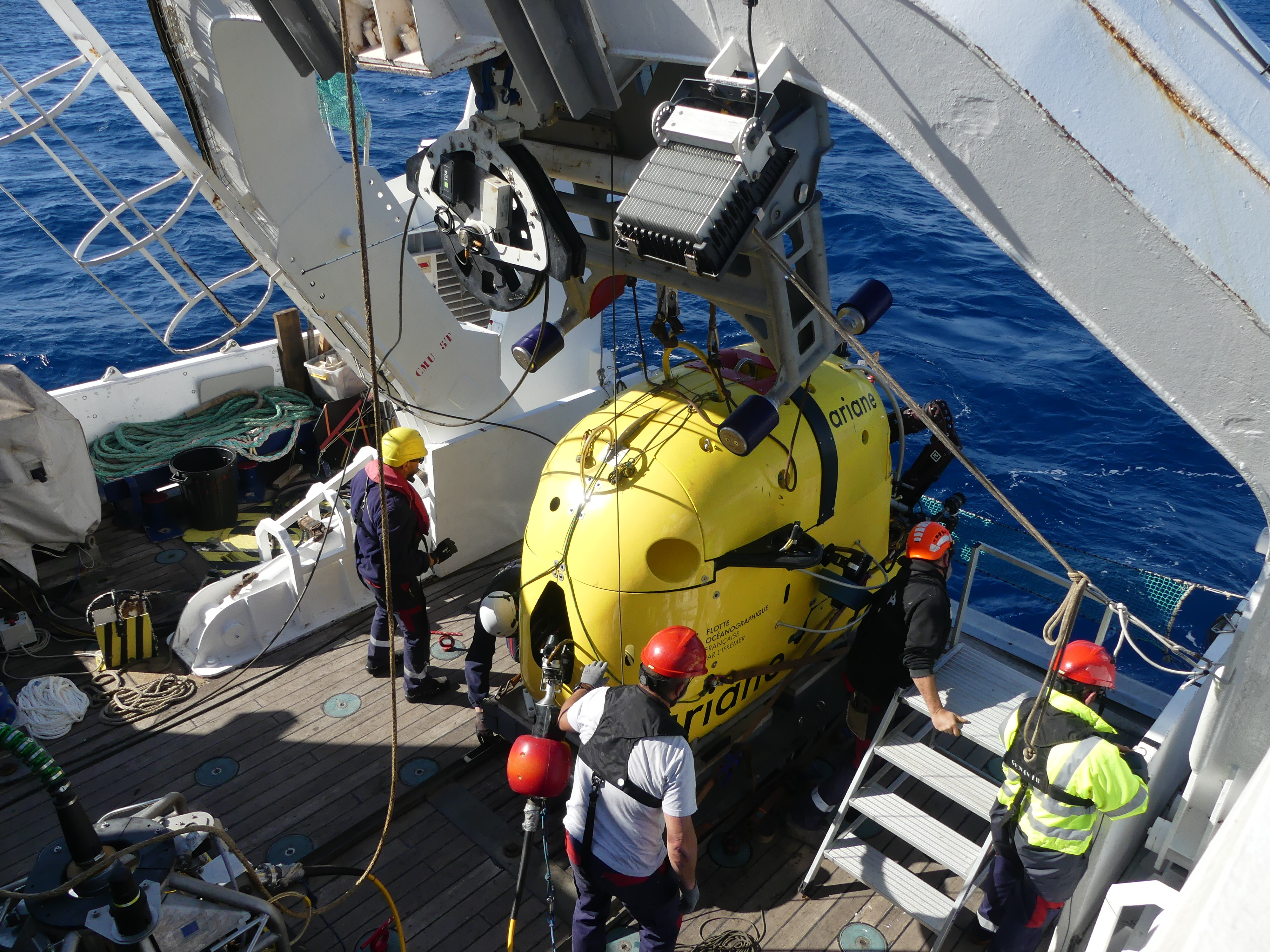
In April 2023, we boarded again R/V Europe, which was carrying this time another deep-sea vehicle: the ROV Ariane. Ariane, remotely operated from the ship through an optical fiber cable, is equipped with cameras that allow us to observe the seafloor in 4K! This thin cable offered it a name : Ariane, named after the legendary Ariadne (Ariane in French) helping Theseus with her thread escape from the labyrinth and the Minotaur. Departing with Ariane on board from Crete, land of the Minoan civilization, we could only find what we were looking for. During 3 weeks, again under bad weather, strong winds and a few nice days, we observed the faults through Ariane, moving close to the seafloor at the pace of 0,5 m/s, and for up to 5 or 6h on the best days. Our targets were areas where the 2023 AUV data showed the steepest faults with the simplest morphologies at three locations previously identified.
Our first dive targets the Amorgos Fault, the most likely candidate to hosting this earthquake, as shown in our study - but we needed dives at the other two faults for comparison and to verify if they hosted or not this major earthquake. Images from ROV Ariane and samples, analyzed after the cruise, revealed that only the Amorgos fault displayed traces of a fresh rupture, and after diving into the historical seismicity of the area, the 1956 earthquake is the only event that could have generated such a recent rupture. 3D models of the seafloor, constructed from ROV Ariane images, suggest that this rupture shifted the seafloor by ~10 m minimum - a displacement that likely occurred in a few moments, and right adjacent to the cliff where, 67 years ago, the two shepherds were standing, looking at the sea, and witnessing the highest wave of this major Mediterranean event. Hence, the rapid seafloor offset due to slip on the fault was probably sufficient to generate the high waves, and that submarine landsliding might not be necessary (while we cannot exclude them).
More than finding a needle in a haystack, we showed that finding the causative faults of old tsunamigenic earthquakes is possible with appropriate strategies and using tools developed for deep-sea research in recent years. Our study opens the path to future surveys that will allow the community to better know the causes of significant submarine natural hazards that occurred in the past, and that could repeat in the future. Finally, this paper and the work performed in the framework of the AMORGOS* project, will improve our understanding of the seismic and tsunami hazard of this part of the Aegean archipelago.
*The AMORGOS project is funded by INSU-Tellus, Observatoire de la Côte d’Azur, Académie 3 (Idex - Université Côte d’Azur), Flotte Océanographique Française, Géoazur laboratory, and Agence National de la Recherche.
Follow the Topic
-
Communications Earth & Environment

An open access journal from Nature Portfolio that publishes high-quality research, reviews and commentary in the Earth, environmental and planetary sciences.
Related Collections
With Collections, you can get published faster and increase your visibility.
Archaeology & Environment
Publishing Model: Hybrid
Deadline: Mar 31, 2026
Drought
Publishing Model: Hybrid
Deadline: Mar 31, 2026


Please sign in or register for FREE
If you are a registered user on Research Communities by Springer Nature, please sign in