The Erosion Crisis Reshaping Tropical Cities
Published in Earth & Environment and Civil Engineering

These are not your everyday potholes or drainage ditches. Urban gullies are large, deep erosion channels that suddenly form in urban areas, usually along unpaved roads or steep hills. Triggered by heavy rains and poor urban planning, they can grow rapidly, destroy homes and roads, and even claim lives. Once a gully forms, it often grows out of control — becoming a permanent scar in the city’s landscape.
Until recently, these dramatic events were dismissed as isolated “freak accidents.” That is, until a team of Congolese and Belgian researchers decided to join their efforts to investigate the problem. What they uncovered — using freely available satellite imagery and population data — reveals a widespread and pressing issue that has long flown under the radar.
")
An urban gully in Kinshasa (Photo: Matthias Vanmaercke, April 2018)
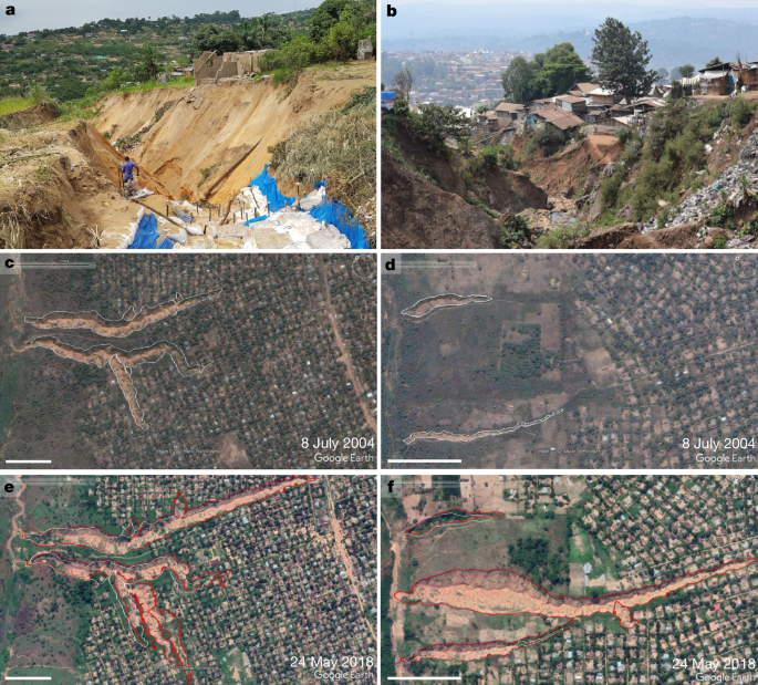
Over 2,900 Gullies, 26 Cities, One Alarming Pattern
Led by Dr. Guy Ilombe Mawe and Dr. Matthias Vanmaercke, the research focused on the Democratic Republic of the Congo (DRC), a country experiencing rapid urbanization. Field observations and preliminary studies in cities such as Kinshasa, Mbuji-Mayi, Kikwit, and Bukavu showed that identifying gullies across such a vast region required a simple yet reliable method. The team therefore systematically analysed thousands of very high-resolution satellite images, manually mapping gullies. This effort revealed over 2,900 urban gullies in 26 cities, together stretching more than 730 kilometers.
Kinshasa, the DRC’s capital, alone had more than 860 gullies. Many were up to 30 meters wide and hundreds of meters long, often right in the middle of neighbourhoods. These weren’t small drainage problems; they were gaping wounds tearing through the fabric of the city.
Where Erosion Meets Human Lives
Urban gullies are more than an engineering headache — they are a humanitarian crisis unfolding in slow motion.
By tracking gully expansion between 2004 and 2023 and combining this with population density data, the researchers estimate that over 118,000 people were likely displaced during this period. In recent years alone, as many as 12,000 people per year may have lost their homes. The impact falls hardest on residents of informal settlements: communities with few resources to relocate or rebuild, and little support when disaster strikes.
What is even more alarming is the pace of acceleration. Since 2010, the number of people living near urban gullies has doubled. By 2023, more than 3.2 million people were residing in zones at risk, with about 550,000 in areas considered high risk — where homes could easily be lost within the next decade.
Overall, 2.6% of the DRC’s population currently lives within 100 meters of a gully — an exposure level comparable to the risks posed by floods or earthquakes elsewhere in Africa. With urban populations projected to triple by 2050, and rainfall expected to intensify under climate change, the threat is set to grow even more severe.
")
Once formed, urban gullies often continue to cause destruction for many years (Photo: Matthias Vanmaercke, April 2018)
Why Are Urban Gullies Forming?
At first glance, gullies might look like a natural consequence of Africa’s climate and landscapes. Heavy tropical rains, steep slopes, and sandy soils create the perfect conditions for erosion. But these factors alone don’t explain why gullies have become such a widespread urban problem. With the right infrastructure, their formation can be prevented.
The real trigger is rapid, unplanned urban growth. Across the DRC, as in much of the Global South, cities are expanding quickly under the pressure of population growth and rural migration. Too often, houses and roads are built on fragile slopes without considering how water flows. Drainage systems, retention basins, or rainwater storage facilities are usually absent.
When the rains come — and in tropical Africa they can be intense — water rushes over rooftops and streets, gathering speed and volume. With nothing to slow it down, the runoff tears into the soil. Roads in particular act like funnels, which is why 98% of the gullies mapped in the study were directly connected to them.
Once formed, gullies rarely stop — they continue to widen and lengthen over decades, tearing into homes and forcing families to leave. The result is a slow but relentless reshaping of cities — one that could largely be avoided with better planning and infrastructure.
What Can Be Done?
Fixing existing gullies is expensive — stabilizing just one can easily cost over a million US dollars. Yet the research suggests that prevention is possible and far more cost-effective.
The keys lie in:
- Better urban planning, especially in hillside areas.
- Proper road construction with drainage systems that are maintained.
- Retention basins and cisterns to capture and store rainwater before it runs downhill.
- Vegetation to hold the soil together (though this alone isn’t enough).
To do so, governments, NGOs, and international partners must recognize urban gullies as a serious hazard — and act accordingly. New risk maps, predictive tools, and early-warning systems could help cities manage growth more safely.
This research offers a critical first step by presenting a detailed, country-wide inventory of urban gullies in the DRC, as well as a first predictive model highlighting the most susceptible areas. Importantly, both the data and tools developed in this study are openly available, providing a valuable resource for planners, researchers, and policymakers aiming to tackle this growing risk.
")
Proper drainage infrastructure is often key in the prevention and mitigation of urban gullies (Photo: Matthias Vanmaercke, November 2019)
Conclusions: A Preventable Urban Disaster
Urban gullies may not grab headlines, but their toll is mounting — carving through cities, destroying homes, and displacing families. Driven by rapid urbanization, intense rains, and fragile infrastructure, the threat is set to grow as African cities expand and climates shift.
Yet this is not inevitable. With the first national-scale maps, data, and predictive tools now in hand, there is a clear chance to act. Smarter planning and better infrastructure can stop gullies before they start. The challenge is urgent, but the solutions are known — making this a crisis we can prevent.
Follow the Topic
-
Nature
A weekly international journal publishing the finest peer-reviewed research in all fields of science and technology on the basis of its originality, importance, interdisciplinary interest, timeliness, accessibility, elegance and surprising conclusions.

Related Collections
With Collections, you can get published faster and increase your visibility.
Carbon Dioxide Removal
Publishing Model: Hybrid
Deadline: Jan 16, 2027


Please sign in or register for FREE
If you are a registered user on Research Communities by Springer Nature, please sign in